A room with a view

If you’re fortunate on a visit to Seattle to have clear skies, even though it is nearly 100 miles away, Mt. Rainer appears to loom over the city. We followed that beacon to stay at the National Park Inn for an even better view of the volcano.

National Park Inn, Longmire, Washington

We stayed here 29 years earlier, and like the others sitting out on that front porch, got a view of the mountain that remains etched in your mind.

Mount Rainier National Park

A bit further up the road, you can pull over for a view of some of that melting snow and glacier tumbling down what is called Christine Falls. And if you’re lucky, catch a rainbow.

Christine Falls, Mt. Rainier National Park

In May, the road is only plowed up to the Paradise Visitor Center. If you have crampons and ropes, you can climb to the summit from there. However, we were content to rent snowshoes and simply enjoy the quiet and the views.

Between me and the noise of strife 
    Are walls of mountains set with pine;  
The dusty, care-strewn paths of life  
    Lead not to this retreat of mine.  

Alexander Posey, My Hermitage

I listen to a podcast called Poetry Unbound. Host Padraig O’Tuama usually recites and explores a contemporary poem. But this week, he shared The Dew and the Bird from Creek Nation poet Alexander Posey (1873-1908).

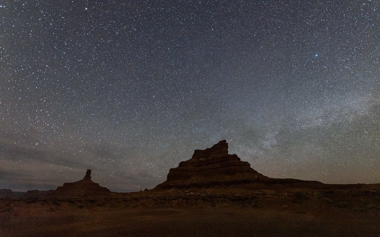
Before going to sleep at the National Park Inn, I set up the tripod near the front porch and enjoyed the stars. While looking skyward, I heard some noise, and looking down about 20 feet in front of me a pair of deer were chewing on the newly emerged grass and newly emerged frogs sang in the creek nearby.

I hear the river flowing by  
   Along its sandy bars;  
Behold, far in the midnight sky,  
    An infinite of stars!  
 
‘Tis sweet, when all is still,  
   When darkness gathers round, 

Alexander Posey, My Hermitage

Mt. Rainier night sky

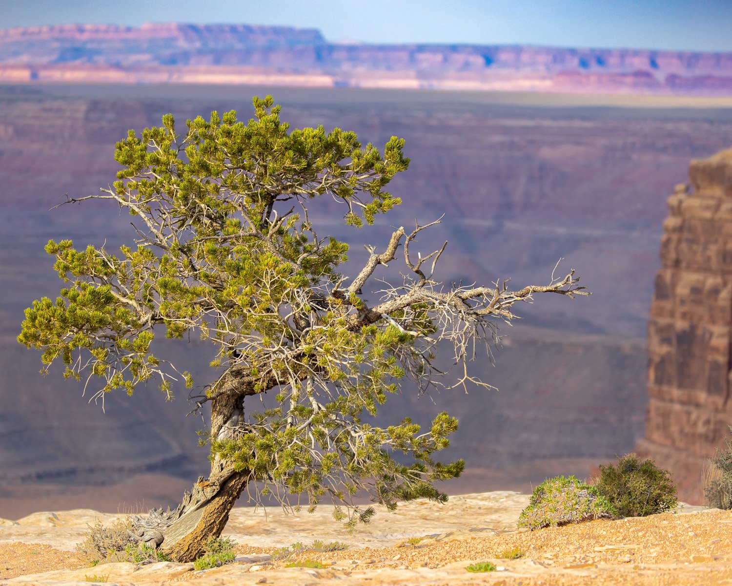
While enjoying breakfast the next morning on the Inn’s porch, a Steller’s Jay checked whether we enjoyed the view and would leave some food behind.

There is more sweetness in a single strain

    That falleth from a wild bird’s throat,

At random in the lonely forest’s depths,

    Than there’s in all the songs that bards e’er wrote.

Alexander Posey, The Dew and The Bird

Steller’s Jay

Valley of the Gods

On the Navajo Nation along the Arizona-Utah border lies Monument Valley. Its iconic Southwest movie backgrounds have places names such as John Ford and Forest Gump points. Just north, is a smaller version of red sandstone monoliths and buttes named Valley of the Gods.

Cedar Mesa and Valley of the Gods

The area is now the southwest corner of Bears Ears National Monument. We arrived in the late afternoon with the mist silhouetting the buttes rising to Cedar Mesa in the west. The next morning we drove up a bizarre, twisting road called the Moki Dugway to get to the top of the Mesa. The next image is from that road looking back down into the Valley again backlit by the sun.

We camped below a feature named Sitting Hen Butte. It’s hard to appreciate the size of it in the first drone image below, but in the second you can compare the white boulders to the size of my car in our campsite.

Cracked eggs below Sitting Hen

In the next image, the drone is above Sitting Hen and looking toward its companion Rooster Butte. As a drone novice, I flew the drone behind Sitting Hen and lost the signal. Fortunately, the drone is smarter than I, and after a few minutes of worry, returned to the nest.

I’d chosen the site below the buttes in hopes of a foreground for a night sky image with the chickens on their roosts.

In the early morning, more clouds were forming as the sky began to brighten.

We got back on the seventeen mile road that winds through the valley to get some images in the early morning light.

Though Monument Valley has served as a backdrop of many movies, Valley of the Gods seems to have much fewer scenes. Apparently, a couple Doctor Who episodes were filmed here. In one of the most bizarre movies ever, John Malkovich starred as the world’s richest man in the 2020 movie Valley of the Gods in which he buys the place for mineral exploitation. You can watch it on Amazon Prime—or at least the first 5 minutes which has some nice images of the Waterfold Pocket and Cathedral of the Sun in Capitol Reef, the Moki Dugway, Valley of the Gods, Shiprock Butte (on which Malkovich’s character builds his estate), and the Goosenecks which is just on the other side of Cedar Mesa. The next picture is just where the actor stands, and I could tell how their drone flew to avoid showing the railing I stood behind to take this shot.

Goosenecks State Park, Utah

The meanders of the San Juan River provide a dramatic site at Goosenecks State Park, just a short way upstream is the Muley Point overlook of the San Juan in Glen Canyon National Recreation Area. Within a thirty mile drive are a remarkable collection of sites — Valley of the Gods and Cedar Mesa, Bears Ears National Monument, Moki Dugway, Muley Point, Glen Canyon, Goosenecks State Park and in the distant view—Monument Valley.

Muley Point, Glen Canyon National Recreation Area, Utah

Temples of Sun, Moon & Stars

After leaving San Rafael Reef and the Factory Butte area, I headed up a favorite backroad I’d ridden twice before on the east side of Capitol Reef National Park. So why are there reefs in the middle of the desert? As pioneers traveled, the long folds in the planet’s crust were impossible to go over and difficult to get around. They recalled coral reefs that impeded ship travel. Here, the nearby white domes of Navajo Sandstone led the Mormon settlers to think of the new dome in the national capitol, and so it was named Capitol Reef.

Cottonwood in the Fremont River Canyon, Capitol Reef National Park, Utah

Capitol Reef is part of the 100 mile Waterpocket Fold, and the long, narrow park runs along this geologic feature. Cathedral Valley is a remote section in the northeast part of the park filled with monolithic features that rise out of the desert floor like gothic cathedrals. Two of these are named Temple of the Sun and Temple of the Moon. As I planned the trip, I was not thinking of going this far west or returning to this park. However, as I studied the calendar, I saw I’d be near these features around the time of the new moon—the darkest nights in one of the darkest places. The temples could be dramatic foreground elements for photos. I’d just need clear skies. Write it in the itinerary and hope for the best.

You can only camp in designated campgrounds in national parks. However, Cathedral Valley Road runs mostly on Bureau of Land Management property next to Capitol Reef, and boondocking on BLM land is usually no problem. I figured I could find a camping spot near Temple of the Sun, and bingo, right outside the park boundary was a nice site for the night. In the Google Map below, Park land is in tan, and my camp was on the white BLM land a mile from Temple of the Sun.

After finding camp and making dinner, Chance and I explored around the two monoliths looking for potential spots to find in the dark. The blue sky held promise for clear night skies. The dreams I’d planned were clicking into place.

Temple of the Sun, Capitol Reef

After some good sleep in the cool desert night, it was time. The clouds had stayed away. The Milky Way arced across the sky. Constellations beamed down. Even on a moonless night, stars alone provided an amazing amount of light. And the sight was wonderous.

Temple of the Sun

Chance laid by the car while I walked around Temple of the Sun, hoping Scorpio stayed in southern sky and didn’t send any relatives to the ground. An occasional shooting star seemed to provide music in the silence. Time to take a short drive over Temple of the Moon and capture some image there. Very soon, some faint light started glowing on the horizon. A few misty clouds began forming.

Temple of the Moon

Just ten days before I’d proclaimed one of my favorite verses at the Easter vigil:

And so it happened:

God made the two great lights, the greater one to govern the day, and the lesser one to govern the night; and God made the stars.

God set them in the dome of the sky, to shed light upon the earth, to govern the day and the night, and to separate the light from the darkness.

God saw how good it was.

As the stars began to fade, it was time to get back on Cathedral Valley Road and head toward the highway. There were still plenty of stops to enjoy the morning light and watch the park features waking up.

The road climbed over Bentonite hills before getting to the highway. Some of the Native Americans called this area “Sleeping Rainbow.” As the sun was reaching the horizon, the cloud cover increased. Time for breakfast. The clear skies, the night, and the stars were gone. And it was very good.

San Rafael Swell

Tucked between Canyonlands and Capitol Reef National Parks in south central Utah is the San Rafael Swell. The Swell is dome of sandstone, limestone and shale about 40 by 75 miles and has been carved and eroded with canyons, mesas and buttes. We camped near the trailhead for Little Wild Horse Canyon and hiked in before dark.

The wash that flows out of the canyons provides enough moisture to support some large cottonwood trees. The next morning we’d take another hike in Goblin Valley State Park that is behind the ridge seen in the distance in the image above. As the trail heads up into the swell, the canyon begins to narrow.

Eventually, the trail leads to the entrances for two slot canyons. Bell canyon breaks off to the left, and we went right to Wild Horse Canyon. If you have time, you could take either canyon to its end and loop over and return up the other for an eight mile hike.

The water has cut fantastic shapes and textures into the canyon walls. Though there’s a small bit of scrambling on some rocks, it is in no way a technical hike and you’re not going to get stuck with a boulder on your arm.

The trail gets narrower and walls get higher. The trail can be popular, but we had the evening walk all to ourselves.

Before getting too far up the canyon, we turned around to get back to camp before dark, especially since we’d need to get an early start for Goblin Valley State Park the next morning.

Before the sun rose, the waning moon, Venus and Jupiter peaked over the ridge in the east.

The sun soon followed and danced behind the figures in Goblin Valley.

The cold morning would warm up quickly but the snow still lay on the La Sal Mountains in the distance. The waves from the ancient sea bed seemed to crash around.

The valley was filled with sandstone eroded into fantastic shapes. This, too, can be a popular area, but our early start meant we had the place to explore on our own until we headed back and others began to hike among the goblins.

Chance found some of the shapes to be comfortable places to rest before we’d head back to car and explore some rough roads into and around the San Rafael Swell and other fantastic formations on our way toward Capitol Reef National Park.

The Fourth Sign of the Zodiac -- by Mary Oliver

Today starts National Poetry Month—no foolin’. I just listened to a rebroadcast of a 2015 podcast interview with poet Mary Oliver. I mentioned in an earlier post that I only learned about Oliver’s poetry after I read her obituary in 2019. Much of her imagery and metaphor come from her walks in nature and her incredible observation.

If you’d like, you can listen to the entire 49 minute podcast here or if you choose, the entire hour and a half unedited interview which is even better: On Being: About halfway through the interview, she reads her four-part poem The Fourth Sign of the Zodiac written after her encounter with lung cancer. Some excerpts of the poem accompany the images below.

Carlsbad Caverns National Park, New Mexico

The question is,
what will it be like
after the last day?
Will I float
into the sky
or will I fray
within the earth or a river—
remembering nothing?

from Part 2, The Fourth Sign of the Zodiac, Mary Oliver

The main reason to visit this park, of course, is the cavern. The second reason is to experience the whir of thousands of bats swarming out of the cave at dusk, some zooming a few feet over your head. An unexpected bonus of the park was walking through the Chihauhaun desert. In the image above, we were blessed with a striking setting sun over the Permian Basin.

Moonrise, White Sands National Park, New Mexico

I know, you never intended to be in this world.
But you’re in it all the same.

so why not get started immediately.

I mean, belonging to it.
There is so much to admire, to weep over.

And to write music or poems about.

Bless the feet that take you to and fro.

from Part 3, The Fourth Sign of the Zodiac, Mary Oliver

The fierce wind the evening pictured above at White Sands blew sand into your clothes. The wind began to settle a bit as the sun set. On a distant dune, three people sat to watch the moon rise in the sky.

Purple Sand Verbena, White Sands National Park

The Purple Sand Verbena is a desert member of the Four O’Clock family. Natives used it as a sedative to reduce nervousness, anxiety, and tension. I suppose that is from consuming it. Seems like just looking at it can have a similar effect.

Late yesterday afternoon, in the heat,
all the fragile blue flowers in bloom
in the shrubs in the yard next door had
tumbled from the shrubs and lay
wrinkled and fading in the grass. But
this morning the shrubs were full of
the blue flowers again. There wasn’t
a single one on the grass. How, I
wondered, did they roll back up to
the branches, that fiercely wanting,
as we all do, just a little more of
life?

Part 4, The Fourth Sign of the Zodiac, Mary Oliver

If you’d like to hear Oliver read the entire poem—and I encourage it—you can find it here. Or you can read it here. And an interpretive footnote—Keats was 29 when he died.