A dash of salt

I’ve visited Salt Lake City five times, but had never been to the shore of the Great Salt Lake. The airport rests on the edge of the lake and the flight approach often goes over the lake. The Natural History Museum of Utah has a terrific exhibit on the ecology, hydrology and geography of the lake. When I visited Golden Spike National Historical Park, there were signs for a drive over ranch land to the Spiral Jetty. It was mid-day—not a good time for photography usually, but my curiosity prevailed, and it was time to visit the lake.

Spiral Jetty, Great Salt Lake, Utah

Spiral Jetty, Great Salt Lake, Utah

Standing on the ridge above the lake, it looks like a weird mirage of mountains in the distance. It is odd to smell the salt air as if you’re on the ocean coast. The 1,500 foot long, 15 foot wide jetty coils out from the shore. It is sometimes submerged under water, but the lake is low and so the water was quite a distance from the jetty built in 1970 by sculptor Robert Smithson.

It gets stranger walking past the jetty to the lake. The north arm of the Great Salt Lake was cut off from the rest of the lake when a train causeway was built by the Southern Pacific Railroad. The ocean is about 3.5% salinity. Most of this lake is about three times saltier. The north arm has a 27% salinity! Red salt-tolerant bacteria and algae and a few weird insects live in the water.

Red water reflections

Red water reflections

The small islands and the ripples in the shallow, red water enhance the other-worldly feel.

Sunburst, Great Salt Lake

Sunburst, Great Salt Lake

Comma

Comma

GSL north arm islands (1 of 1).jpg

What in the distance looks like salt or ice crystals near the edge of the water, turn out to be mats of foam and bubbles. The very slow waves and surge of the lake cause the foam mats to shutter and sputter and act like some primordial life coming out of the lake. I was very happy the hikers in the distance wore red jackets.

Salt foam

Salt foam

Hikers looking at foam forms

Hikers looking at foam forms

My shoes still have some salt marks from this odd hike to this weird, huge desert lake.

Islands and mirages

Islands and mirages

North Arm reflections

North Arm reflections

Appetizer

The hamlet of Fionnphort sits on the western edge of the southern arm of the Island of Mull—called the Ross of Mull. The ferry leaves Fionnphort for the short trip across to the island of Iona. My B-and-B proprietor suggested I walk next door to make a reservation for dinner at The Keel Row. I reserved the last available time hoping I could get some sunset images before dinner, and I took my camera across the road to the cove that looked over to Iona. Low tide beached a boat in the mud.

Fionnphort beach, Isle of Mull

Fionnphort beach, Isle of Mull

Walking further down the wet sand to beach to view the red granite across the cove catching the sunset light.

Fionnphort cove -2.jpg

Fionnphort means white sands or white port, but as the tide went out the ripples looked quite dark.

View across to Iona

View across to Iona

Time to walk back up to the top of the cove and get a final shot before dinner.

Fionnphort sunset over Iona

Fionnphort sunset over Iona

Angels

I’m looking forward to a visit to Zion National Park in Utah this winter, and getting a different view of this wonder. One trail I likely won’t be taking this time is Angel’s Landing, one of the most magnificent hikes in the National Parks. The trail starts by crossing the Virgin River in the valley floor.

Virgin River, Zion National Park

Virgin River, Zion National Park

Soon you are gaining elevation on switchbacks and slow ascents, and get a nice view down to the river and the valley that it formed.

Angel’s Landing trail and Zion valley

Angel’s Landing trail and Zion valley

Soon enough the trail gets more adventurous with warning signs and chain assists.

Chain cable assist

Chain cable assist

View from Scout Lookout

View from Scout Lookout

Angel’s Landing got its name from a Methodist minister who viewed the cliff and remarked that only angels could land there. The last leg of the hike has chains most of the way to have something to hold on to while looking at 1000 foot drops on both sides of the narrow trail.

Final hike on the rocky spine

Final hike on the rocky spine

We decided that this landing place had a good enough view to stop for a snack. I’ll look for a different trail in the snow and ice of January!

View across to the East Rim

View across to the East Rim

View up Zion Valley

View up Zion Valley

A Walk in the Woods

Some more images from the transition from autumn to winter. First, a view on the river in Matthiessen State Park, and then a more intimate scene on the forest floor.

Vermillion River, Mattiessen State Park, Illinois

Vermillion River, Mattiessen State Park, Illinois

Lichens and Leaves

Lichens and Leaves

And a hike in Illinois Canyon in Starved Rock State Park.

Sunlight on the snowy leaves

Sunlight on the snowy leaves

Sunburst

Sunburst

A Revolution

Tuesday morning was time for a walk through the autumn colors at Morton Arboretum before they all would fall. The primary color was the yellow of the maples.

A creek through the maples

A creek through the maples

Spotlight on the yellow maple

Spotlight on the yellow maple

The was a bit of orange and reds among the oaks, and a few others were enjoying the trails.

A walk among the maples frames by some oaks

A walk among the maples frames by some oaks

An old oak

An old oak

A single revolution and autumn changed to winter with a good snowfall the next morning. Some of the leafy branches weighted down with the wet snow broke off to the ground.

Paperbark hazelnut

Paperbark hazelnut

Winter oaks

Winter oaks

The trail led from the oak forest to the trees of China, and I traveled about a half century. When I was 9 or so, I wanted to be an archaeologist, and would show off my rock collection. A friend of my dad’s said he collected fossils. Then next time he visited, he gave me a small collection he labeled and mounted. The star was a ginkgo leaf which he told me was a living fossil. It lived before the time of the T. Rex and was still growing. Here was copse of ginkgos with their fan-shaped leaves turning gold.

Under the ginkgo trees

Under the ginkgo trees

Ginkgo window

Ginkgo window

The trees canopy and envelope each other, telling stories of the day, the season, or an epoch. And sometimes of a kindness done long ago.

Autumn umbrella

Autumn umbrella

Winter hugs

Winter hugs

Blue Horses

If I ever need to be delighted with language, art, heart, earth, hearth, I only need to read a Mary Oliver poem. Here are excerpts of four of her poems from her 2014 book Blue Horses, and some images from Scotland. Choosing only a few lines from a poem fails to convey all its wonder and craft, so it’s best to get the book and read the whole.

Glencoe stream

Glencoe stream

Stebin’s Gulch

by the randomness

of the way

the rocks tumbled

ages ago

the water pours

it pours

it pours

ever along the slant

. . . .

as for purpose

there is none,

it is simply

one of those gorgeous things

that was made

to do what it does perfectly

and to last,

as almost nothing does,

almost forever.

Loch Ness trail

Loch Ness trail

Drifting

I was enjoying everything: the rain, the path

wherever it was taking me, the earth roots

beginning to stir.

I didn’t intend to start thinking about God,

it just happened.

How God, or the gods, are invisible,

quite understandable.

But holiness is visible, entirely.

. . . .

Iona shoreline

Iona shoreline

Do Stones Feel?

Do stones feel?

Do they love their life?

Or does their patience drown out everything else?

When I walk on the beach I gather a few

white ones, dark ones, the multiple colors.

Don’t worry, I say, I’ll bring you back, and I do.

. . . .

Island of Mull

Island of Mull

Franz Marc’s Blue Horses

. . . .

I don’t know how to thank you, Franz Marc.

Maybe our world will grow kinder eventually.

Maybe the desire to make something beautiful

is the piece of God that is inside each of us.

Now all four horses have come closer,

are bending their faces toward me

as if they have secrets to tell.

I don’t expect them to speak, and they don’t.

If being so beautiful isn’t enough, what

could they possibly say?

3 Billion loss

Science magazine published a report last month that the bird population of the United States and Canada has declined by nearly 3 billion birds, or 29 percent, since 1970. Habitat loss and pesticides lead the causes. Grassland birds have suffered the steepest declines. It might just not being in the right place, but often at this time of year I’ve seen great murmurations of huge flocks of blackbirds and haven’t seen as many large groups in recent years.

Red-winged blackbird

Red-winged blackbird

European starlings were introduced to the U.S. in the 19th century and spread far and wide. The report found that even these birds declined nearly by half. Starlings look drab at a distance, but up close have impressive color as this fellow showed off on the Island of Mull.

European Starling

European Starling

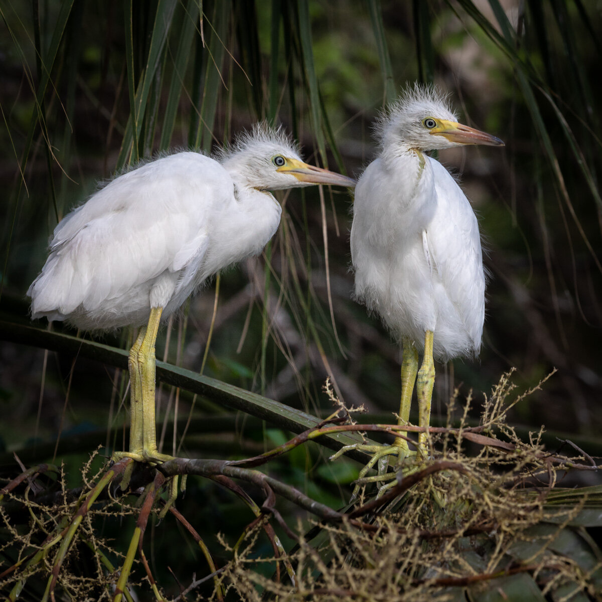
Cattle Egrets are another immigrant. They evolved following large animals in the grasslands of African. They spread to South America in the 19th century. By the mid-20th century they were in North America, and they were very common when I was growing up in Florida following cattle and the insects stirred up.

Cattle Egret chicks

Cattle Egret chicks

cattle egret chicks close-1296.jpg

And the birds aren’t the only ones with a wide mouth. Nests such as this are often over water which makes it harder for predators to get to the trees. However, if the chicks fall out they become a quick snack.

American Alligator

American Alligator

Audubon magazine also reports the devastating effect of climate change on bird range and habitats. Many species faced near extinction a century ago when their plumage was harvested for fashion. Many, like the Great Egret below, made a great recovery, and now face the risk of climate change and habitat loss.

Great Egret chick

Great Egret chick

Dreaming of Utah Autumn

The leaves are just beginning to change here. I got a promo email yesterday about fall colors in Utah. I was there two years ago this week and was completely surprised by the incredible autumn colors. I had no idea.

Aspen in Cache National Forest

Aspen in Cache National Forest

Powder Mountain

Powder Mountain

Highway 39 view

Highway 39 view

Google Maps timeline can be a bit creepy if you allow it to track where you go. However, I find it a great help with reminding me of photo locations. I just check where I was that day, and it often shows where I stopped for a while to take some images. The images above are from the Uinta-Wasatch-Cache area northeast of Salt Lake City. The next two are by Causey Reservior in that area. The sign said a boy scout camp was in the area of this photo.

Causey Reservoir

Causey Reservoir

resiviour-7010.jpg

Just west of Salt Lake City is Emigration Canyon where the Mormons first came into the valley.

Emigration Canyon, Utah

Emigration Canyon, Utah

Lake, pond, bay, inlet, strait? Let's just call it a loch.

Freshwater, brackish or seawater, it seems nearly every body of water in Scotland is called a loch. Two weeks ago I posted some images from Suidhe viewpoint, also called seven lochs viewpoint from small inland lakes to the huge Loch Ness. Here’s some images of Loch Linnhe. It is the southwestern part of the Great Glen Fault that runs NE to SW through Scotland and includes Loch Ness. Linnhe is a saltwater inlet. Here’s a little bay on the northeast end. I discovered what a walking on a Scottish bog is like when one step is on solid ground and the next step which looks the same is suddenly shin deep in muck.

loch lehinn-2.jpg
loch linhe boat-4586.jpg

Down near its wide south end, a storm was brewing on the other side. So what does Linnhe mean in Gaelic? Well, “pool,” of course.

loch linnhe-2.jpg
loch linhe 2-2.jpg

Scottish gardens

While Scotland is full of natural beauty, the formal gardens are stunning as well. Even in late August and September as fall colors begin to appear, the gardens are filled with flowers I’m used to seeing in the spring. Visiting the gardens is not just season shifting, but era shifting. You can step back to 1604 when a magnificent Renaissance walled garden was designed at Edzell castle. The checkered recesses in the walls would have been painted blue and white to mirror the Lindsay family’s heraldry. The walls have carved plaques of mythological and natural symbols.

Edzell Castle walled garden

Edzell Castle walled garden

Edzell garden wall-niches 0121.jpg

The entire Edzell castle buildings and gardens likely could all fit inside the Victorian walled garden at Scone Palace.

Scone Palace walled garden

Scone Palace walled garden

Scone has a star-shaped maze of green and copper beech trees inspired by the Murray family crest.

Scone Palace Star maze

Scone Palace Star maze

Several gardens had tree arbors where the branches intertwined into arches, but none were more impressive than the ones at Scone. I also learned a new term—Pinetum. This collection of pines and conifers includes a Douglas Fir grown from a seed David Douglas sent from America in 1826 for the tree named after him. Douglas had been a gardener on the palace grounds. The pinetum has a wonderful trail of wood sculptures of scenes from Macbeth.

Tree arbor

Tree arbor

Macbeth trail at Scone pinetum

Macbeth trail at Scone pinetum

Another location Shakespeare used in his Scottish Play was Cawdor Castle. Like Scone, it is still lived in and has a wonderful garden.

Cawdor Castle gardens

Cawdor Castle gardens

The capital city of Edinburgh has glorious gardens throughout the city and the Royal Botanic Garden just a mile from the city center.

Edinburgh Castle and Princes Street gardens

Edinburgh Castle and Princes Street gardens

Royal Botanic Garden, Edinburgh

Royal Botanic Garden, Edinburgh

Ravens in the Japanese garden

Ravens in the Japanese garden

Thistle: National Symbol of Scotland

Thistle: National Symbol of Scotland

Loch Ness 360

For decades, Loch Ness lived in my imagination as a tiny dot far north in Scotland, with an occasional grainy image of monster lurking in the depths. We were fortunate to stay several days on the shore of Loch Ness in a Victorian lodge on a site where a lodge for travelers likely existed for five centuries. Living near Lake Michigan, I’m used to orienting my life on the edge of a big lake over which the sun rises in the morning. While the sun rises in the east here, too, they call this the “south side” of the loch. Here’s the morning sun view from the Foyers Lodge on the south side. I’d call it the west side.

Loch Ness sunrise

Loch Ness sunrise

To promote visitors to the area, there is an 80 mile hiking/biking/horse trail around the loch called Loch Ness 360 degree. If you want to hear some Scottish sounds, there’s a delightful interview this month by BBC radio about the trail that starts 13 minutes into this podcast. We hiked a section of trail just behind the Foyers Lodge.

South Loch Ness trail to Inverfarigaig

South Loch Ness trail to Inverfarigaig

Inverness is on the upper end of the Loch and Fort Augustus on the lower. Loch Ness is part of the Great Glen that cuts all the way across the country from the northeast to the southwest. A single track road follows much of the trail for a climb up into the mountains over the loch and some spectacular views. The road runs right beside a beautiful Loch Tarff, and then rises for a distant view.

Loch Tarff

Loch Tarff

Suidhe Chuimein viewpoint

Suidhe Chuimein viewpoint

The Suidhe viewpoint has a sign about viewing seven lochs including Loch Tarff shown above and Loch nan Eun below with waterfalls streaming down the cliffs to the loch.

Loch nan Eun

Loch nan Eun

GPS navigation said Urquhart Castle was only 4 miles from the lodge. However, it would require a boat to travel those few miles to other shore. It would take about an hour on the adventurous single track road to get to the ruins of this castle. Some of the buildings date from the 13th century, but the fortification was blown up in 1692 to prevent the Jacobites from using the castle.

Loch Ness from above Urquhart Castle

Loch Ness from above Urquhart Castle

The clouds and streams of Glen Coe

Glencoe cascade clouds scottish highlands-6007.jpg

I can’t say I know Glen Coe. I haven’t hiked it. Haven’t explored the peaks. Haven’t ridden the River Coe. But I’ve driven the A82 through it. Twice. And stopped for a few images. And the scenes will be indelible in my mind.

The steep glen walls just weep with streams. It was misting and raining both times driving through, but still, you question: How can there be that much water?

Glencoe cascade clouds-3836.jpg
Glencoe cascade-3841.jpg

The heather, trees, clouds and rocks make it both stark and soft at the same time.

Glencoe trees-Scotland clouds 3858.jpg

The first time through, there was a heavy mist, but the sun peaked through and glowed at times. The second, was a steady rain.

Glencoe road-2.jpg
Glencoe mist-cottage glow.jpg

The Lady of Loch Ness

No monsters were seen on the Loch, but we were given directions to a waterfall in a nearby glen. You turn by the garage for the sign for the cemetery (accents on the first syllables of “garage” and “cemetery,” don’t you know.) You’ll walk through the graveyard, and find steps over the cemetery wall.

Lady falls cemetery stairs-3380.jpg

You’ll continue along a farm and see lots of sheep.

Lady falls wall-2.jpg

The paths will be green, and you’ll get soaked in the rain and while rubbing against the ferns crowding the trail, but the trees will point the way.

Lady falls green trail-3061.jpg
Lady falls curve oak-3274.jpg
Lady falls oak drama-2.jpg

There may be some locals who keep an eye on you so you don’t disturb the heather and the aspen.

Lady falls ferns heather-2.jpg
Lady falls deer-3073.jpg

Finally, you will be presented to the Lady in her white gown.

Lady falls fall path-2.jpg
Lady falls falls-2.jpg

103: 419, 61

The National Park Service celebrated its 103 anniversary this week. There are 419 park units including National Memorials, National Historic Sites and National Preserves, but the premier status is that of National Park of which there are 61. They are of incredible diversity, and present great photo opportunities. Let’s start with some wide scenes, and what’s grander than the Grand Canyon in Arizona?

Sunset on the North Rim, Grand Canyon National Park, Arizona

Sunset on the North Rim, Grand Canyon National Park, Arizona

North of the Grand Canyon are more spectacular desert vistas in southern Utah. The greatest collection of natural arches is in Arches National Park, and here’s Double Arch with some hikers to give perspective.

Double Arch, Arches National Park, Utah

Double Arch, Arches National Park, Utah

The park service protects the highest spot in the continent at Denali, and here’s the lowest—Badwater Basin in Death Valley.

Badwater Basin, Death Valley National Park, Nevada

Badwater Basin, Death Valley National Park, Nevada

Those are all pretty barren! How about some parks with a focus on preserving incredible biodiversity, and their names reveal the stars.

Sequoia National Park, California

Sequoia National Park, California

Dusk, Saguaro National Park, Arizona

Dusk, Saguaro National Park, Arizona

Two parks preserve remnants of the vast hardwood forests that once covered the eastern portion of the continent. One of the newest parks is Congaree and protects river bottomland hardwood forests mainly of cypress and tupelo. Great Smoky Mountains has vast ridges of high mountain forests. Happy Birthday, National Park Service.

Tupelos along the boardwalk, Congaree National Park, South Carolina

Tupelos along the boardwalk, Congaree National Park, South Carolina

View from Clingman’s Dome on the border of Tennessee and North Carolina, Great Smoky Mountains

View from Clingman’s Dome on the border of Tennessee and North Carolina, Great Smoky Mountains

Out of the mist

How about a bit of a poem from Mary Oliver and some images from a morning at a friend’s place in the Northwoods of Wisconsin. To get the full flavor, you should read the whole poem: Mornings at Blackwater, from Red Bird, 2008, Mary Oliver.

Wisc lake pads pier-7269.jpg

. . . .

What I want to say is

that the past is the past,

and the present is what your life is,

Wisc lake dawn-2.jpg

and you are capable

of choosing what that will be,

darling citizen.

Wisc lake Iris-7187.jpg

So come to the pond,

or the river of your imagination,

or the harbor of your longing,

Wisc lake sun star-2.jpg

and put your lips to the world.

And live

your life.

Wisc lake boat float-7320.jpg

Temperance

A cleverly named river flows into Lake Superior’s North Shore. Most of the rivers have a sand bar that extend out into the Lake, but the Temperance has no bar—thus temperant. Further upstream in Temperance River State Park the Superior Trail leads to a place called Hidden Falls.

Superior hiking trail

Superior hiking trail

Eventually the trail leads to the Temperance River and the falls surrounded by pine, birch, spruce.

IMG_8447-3-2.jpg
Hidden Falls, Temperance River State Park, Minnesota

Hidden Falls, Temperance River State Park, Minnesota

Do you see the doughnut in the image above? There’s often foam in white water that will gather in eddies, but this cove created a five foot toasted coconut doughnut.

IMG_8576.jpg

Some hikers came from the other direction and enjoyed diving into the deep pools by the falls. It is Minnesota after all, so wet suits are good idea even in July.

_MG_6818.jpg

I’ll leave you will a long exposure view of the boulders in the river.

IMG_8513.jpg
IMG_8501.jpg

More fishing

The morning started with some fog over the water.

Fish jump seagull sunrise-8602.jpg

Soon I noticed the water was boiling with fish near shore. The tiny bait fish swirled on the surface indicating big fish were going after them below, and this attracted the birds to after them from above. And a few folks were going after them from aside.

Fish jump beach dolphin-8668.jpg
Fish jump beach-8640.jpg
Fish jump fisherman-8657.jpg

After leaving the beach, and crossing the inter-coastal waterway, I had to pull over because of the beautiful green reflection on the water. There were more fisherman bringing their catch in, dolphins and pelican gathering their catch, but this Great Blue Heron captured my attention. It seemed as if the mullet were teasing him, but he eventually found the target.

Fish jump Great Blue Heron-8368.jpg
Fish jump Great Blue Heron-8337.jpg
Fish jump Great Blue Heron-8347.jpg

Flights of fish

Perhaps you’ll enjoy a flight of beer or wine this evening. This couple enjoyed their flights of fish.

Tricolor heron looking over the menu

Tricolor heron looking over the menu

Selecting the first sample

Selecting the first sample

Tossing back the next delicacy

Tossing back the next delicacy

Snowy herons were on the verge of extinction when their feathers were in high demand for hat fashion. They are petite herons, but aggressive and territorial. You can identify them by their “yellow slippers” which the one below drags along.

Snowy heron dipping in for the first sample

Snowy heron dipping in for the first sample

Selecting number two

Selecting number two

Finishing with a flourish

Finishing with a flourish

Floating on memories

Each spring break in high school, a large group from the Honor Society would load up cars with gear and head to Ocala National Forest and set up camp at Juniper Springs. We’d hike on the Florida Trail, play games around the campfires and on picnic benches, and when it was time to cool off, it was short walk down the trail to the springs.

Juniper Springs, Ocala National Forest, Florida

Juniper Springs, Ocala National Forest, Florida

As with much of the infrastructure we enjoy in our federal and state parks, most of the work here was constructed by the Civil Conservation Core in the 1930s. As you can see in the picture above, where the large pool drains into Juniper Creek, a millhouse and waterwheel was built. The campground and pool were far from any electric lines, so the CCC waterwheel produced electricity for the recreation area.

Juniper Springs Waterwheel and spillway

Juniper Springs Waterwheel and spillway

Juniper Springs Millhouse

Juniper Springs Millhouse

The creek flows on towards the St. John River. A beautiful stone bridge over the creek is closed, but is an exquisite ruin for now. Perhaps, it will be repaired one day. Perhaps, our country will again recognize the value of national service for our young people as a way of enriching our schools, parks, and infrastructure.

Stone bridge, Juniper Springs

Stone bridge, Juniper Springs

While the pool contains the large springs which is the main source of the creek, other spring-fed creeks feed in and at many places along the creek more cool, clear water bubbles up from more springs.

Juniper creek

Juniper creek

The highlight of our annual trip was the canoe run. We’d pack the aluminum crafts with lunch and drinks and head downstream. The beginning of the run is narrow and winding, but eventually widens and flows into the Juniper Prairie Wilderness. The cool water provides a certain place to escape the Florida heat.

Juniper Spr curtain-0264.jpg
Juniper Spr log-.jpg
Juniper Spr river-0142.jpg

Put this in your pipe

On Tuesday, I wrote about Grand Portage National Monument in the far northeast corner of Minnesota. All the way down to the southwest corner is Pipestone National Monument protecting a sacred location for Native Americans. The space does not quickly reveal its treasures surrounded by the tallgrass prairie.

Tallgrass Prairie, Pipestone National Monument, Minnesota

Tallgrass Prairie, Pipestone National Monument, Minnesota

However, as you walk in, the cliffs of Sioux Quartzite begin to appear. The rocks are often covered with spectacular lichen. As beautiful as these rocks are rising out of the prairie, they are not the rock that has been used for nearly 3,000 years by Indians throughout America.

Sioux Quartzite ridge

Sioux Quartzite ridge

pipestone lichen-6962.jpg

The place continues to slowly reveal itself. As you walk further in, the waters of the Pipestone River create a lush environment of plants and trees.

pipestone ridge-.jpg

Finally, you get to the highlight of the hike — Winnewissa Falls. According to lore and oral tradition this beautiful spot in the prairie became a holy place for the area Indians. Just as it slowly reveals itself today, either the river or bison exposed a layer of soft, red pipestone underneath the hard quarzite. The people found this 14 to 16 inch layer was easy to carve and would become a rich, red color.

Winnewissa Falls

Winnewissa Falls

The Indians found the pipestone was easy to carve into figures or pipes, and the red stone developed a beautiful patina with the oils from human hands. Their stories said the red was representative of ancestors blood. The sacred area was recognized as one to share even among warring tribes.

pipestone teepee-6928.jpg

Today, the monument remains a place where dozens of Indian tribes are issued permits to quarry the pipestone each year. The soft stone is called catlinite, named after Philadelphia lawyer George Catlin, who quit his law practice to paint Plains Indians in the 1830s. He documented the quarrying and carving of the pipestone. The Monument has workstations where Native crafters demonstrate their work on the stone.

pipestone carve-7049.jpg
pipestone carve-7034.jpg

Another of the legends at Pipestone offers that you can sit by the feature called the Oracle and receive some of the wisdom this sacred place offers.

The Oracle

The Oracle