Small worlds

A year ago today, I was wandering through Saguaro National Park in Arizona. The big vistas of huge cactus and desert hills is eye-catching, but looking at the tiny environments within the scene is just as fascinating.

Thorny pattern, Saguaro cactus

Thorny pattern, Saguaro cactus

Saguaro NP E 285 flower web.jpg

Plenty of insects survive among desert plants. I’ve no idea what this creature is.

Saguaro NP E 125 bug web.jpg

I imagine it is a challenge for predators to get among the thorns to try to feed on this grasshopper, who seemed quite happy climbing around the cactus.

Among the thorns

Among the thorns

Twilight Zone

I loved Rod Serling’s Twilight Zone. The Dali-inspired intro got you ready for travel to another time and dimension. So let’s journey to another time, though recent events show we haven’t entered a new dimension.

Root cellar, Minidoka National Historic Site

Root cellar, Minidoka National Historic Site

The root cellar is one of the few structures still located in its original site. Minidoka, Idaho was one of many “relocation centers” for people of Japanese ancestry (Nikkei) on the West Coast of the United States. Nearly 10,000 Americans were interred at Minidoka during the War. Afterwards, most buildings, fences, towers were moved or destroyed to try to erase the memory.

Mess hall and barracks, Minidoka

Mess hall and barracks, Minidoka

Some buildings such as the brown mess hall and gray barracks were moved and used elsewhere. Some have been found, and “relocated.” Where I grew up in Florida, barracks like these remained near the airport, a WWII Naval Air Station, which housed German POWs.

Minidoka barracks detail

Minidoka barracks detail

Just a bit north is the tiny town of Arco. It lights up its fame as the first community ever lit by electricity solely derived from the nearby nuclear power plant.

Arco, Idaho

Arco, Idaho

It doesn’t advertise that the 1961 reactor accident was the world’s first, and only U.S., fatal reactor failure killing three people.

Often we just let history fade away.

Arco homestead along the Lost River

Arco homestead along the Lost River

The Lost River Range

The Lost River Range

Morning wood

An uprooted tree at dawn provides some weathered texture.

Taken on top of an old volcano cone at Craters of the Moon National Monument, Idaho.

Dawn at Inferno Cone, Craters of the Moon National Monument, Idaho

Dawn at Inferno Cone, Craters of the Moon National Monument, Idaho

cmnm 3914 wood swirl web.jpg
cmnm 3910 wood swirl web.jpg

A decade

Ten years ago, driving home from Springfield, I stopped for a walk at a park near I-55. One picture I took was of a chicory flower--a "weed" you'll see along roadsides this time of year in Illinois. I sent the image to some friends on Friday, calling it Friday Foto and sharing some of the beauty near our feet. Over the last decade, the images have gone beyond some common roadside sites, but the intent has remained the same: to share the beauty around us.

Chicory flower

Chicory flower

Returning to the roots--or just above the roots--I stopped by a vacant lot in downtown Milwaukee that was filled with Chicory, Queen Anne's Lace and other common wildflowers. Here is a bit of the world along the sidewalk. And, yep, the same chicory whose roots are dried and ground as a coffee substitute or flavoring.

Chicory and hungry bee

Chicory and hungry bee

Getting dusted up

Getting dusted up

Loading up pollen on the leg, and sharing some

Loading up pollen on the leg, and sharing some

The world at our feet

The world at our feet

Up to go down

Timpanogos Cave National Monument is in the Watsatch Mountains in Utah.

Up in the mountains. You need to hike up over a thousand feet from the valley floor to enter the cave. In this image, you can see the road where you start the hike. 

American Fork Canyon, Utah

American Fork Canyon, Utah

Look up to see other hikers and the cave enterance.

Timpanagos Cave hike and entrance

Timpanagos Cave hike and entrance

Once in the cave, you follow old fault lines which have been carved into caverns and are being filled with formations.

Timpanogos Cave National Monument

Timpanogos Cave National Monument

On tour, the ranger explains the formations, such as bacon stalagtites he lights with his flashlight and the cave's big feature, greenish helictites.

Ranger tour

Ranger tour

The helictites are tiny tubes where water and minerals flow through capillarity attraction through the small, capillaries and result in curled, twisting features.

Helictites

Helictites

Outside the cave, there was one outstanding, helictite-like beard.

Timp 3621 beard web.jpg

Ponderosa

The Salmon River runs through a high desert valley that it has carved. One plant that thrives in the environment is the Ponderosa Pine. Its thick, orange bark (that smells like vanilla) surrives most fires.

Salmon River, Idaho

Salmon River, Idaho

However, some intense fires will destroy all, or nearly all, trees in its path.

Lone pine

Lone pine

The tree can serve as a perch to host raptors looking for a fish dinner in the river.

American Bald Eagle

American Bald Eagle

Mars Attacks

While rafting five days on the Salmon River in Idaho, the first night camping in the Frank Church Wilderness was on a meadow above the river. With a dry, clear night forecast, I set up the tripod next to my sleeping bag and set an alarm for when the moon would set and the night sky would be its darkest.

Camping in the Frank Church Wilderness, Idaho

Camping in the Frank Church Wilderness, Idaho

With the tripod and camera ready, I just focused and shot away at the Milky Way in the northeastern sky without needing to get out of my sleeping bag.

Milky Way in the eastern sky

Milky Way in the eastern sky

When the sun rose, some clouds moved in and were a nice subject for a time lapse in the early morning light. (This is the first time I've tried to embed video in the blog. Hope it works. You may need to click on the arrow. Sorry, but YouTube might try to take to you to some other video after mine plays.)

The next night, the campsite was along the river with a view downriver and to the west. The river is the dividing line of Pacific and Mountain time zones, so this image was taken about 10:15 p.m., but it was only 9:15 on the other side. My watch uses GPS and was very confused. The moon was still up and its light covering most of the stars, though Jupiter was along side the moon and you can see it shining through to the right of the moon. I set my alarm for moonset and let the sounds of the river put me to sleep.

Moon and Jupiter above the Salmon River

Moon and Jupiter above the Salmon River

I woke and was stunned by the sight in the dark sky. The Milky Way was glowing, but more amazing, Mars had risen. Though I've seen the planet in dark skies before, never had the planet been so bright and so red. (Unfortunately, the camera sensor was set for the dimmer stars and the red wave length was too bright to record. However, you can see the red color in the planet's reflection on the river.) When I returned home, I read that Mars was in "opposition" to Earth meaning Earth was between Mars and the Sun, and Mars was closer to Earth than it had been since 2003. It glowed 10 times brighter than usual. Adding to the event, Mars is having huge dust storms and reflects redder than normal. I was mesmerized watching it move across the dark sky and its reflection dance along the river as meteors flew about. When the Sun started lighting the sky, it was time to get back to sleep.

Mars and the Milky Way reflecting in the Salmon River

Mars and the Milky Way reflecting in the Salmon River

To the moon

Sorry for not getting any blog postings the last couple weeks. However, I've got a big selection of images from Idaho to share. First, is the barren, high desert, lava field at Craters of the Moon National Monument and Reserve.

Lava field, Craters of the Moon National Monument and Preserve

Lava field, Craters of the Moon National Monument and Preserve

The park was used as a training ground for Apollo astronauts and to learn about volcanic geology. It is now used by some scientists preparing missions to Mars. You can hike caves formed by lava tubes.

Indian Tunnel

Indian Tunnel

After going underground, you can climb cinder cones that spewed lava 2,000 years ago. The main lava flows occurred 15,000 years ago. The giant lava dome under Yellowstone National Park used to be under this part of Idaho.

Inferno Cone trail

Inferno Cone trail

From atop the cinder cone, you can see other volcanoes and lava domes in the distance. One peeks from behind the right side of this tree trying to live on the little bit of soil in the cinders.

Dawn atop Inferno Cone, Craters of the Moon

Dawn atop Inferno Cone, Craters of the Moon

The park is also an International Dark Sky Park. The sky was even darker on the Salmon River. Those images, including a visit by Mars, will come later.

Early morning on Devils Orchard Trail

Early morning on Devils Orchard Trail

Gloamin'

Gloaming is a Scottish word for the dim light in the sky after the sun is down. It's a word in Chicago Cubs lore for Gabby Hartnett's home run 80 years ago before there were lights in Wrigley Field. Darkness descended on the field and the umpires said the September game would end in the ninth inning. The rules then required a suspended game be replayed in its entirety. With the score tied, and two outs and two strikes, Hartnett's ball went into the darkness and landed in the bleachers, and Cubs swept the Pirates and won the pennant--the Homer in the Gloamin'.

Gloaming street, Edinburgh, Scotland

Gloaming street, Edinburgh, Scotland

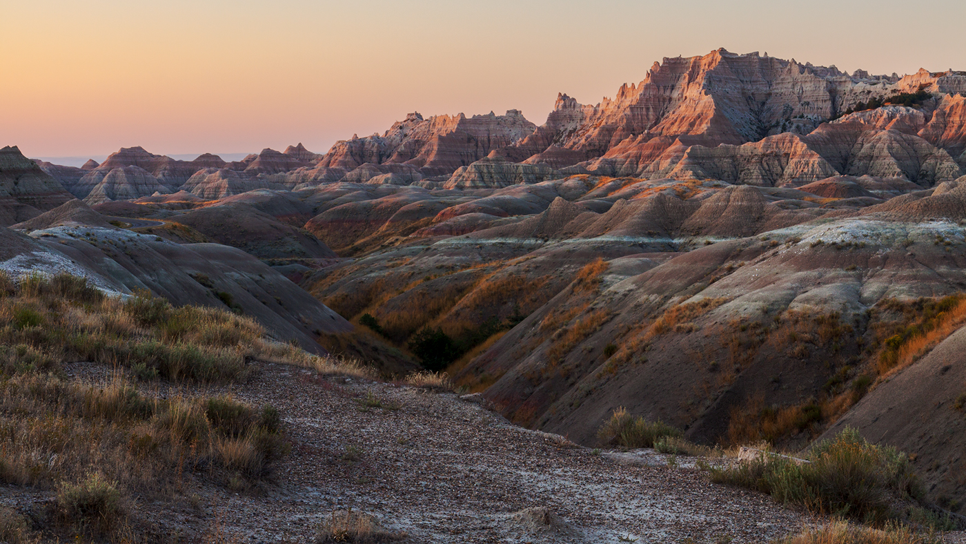
I experienced a beautiful display of gloaming skies a few years ago at Badlands National Park, South Dakota. The sun had set but the last light was still reflecting off the west-facing peaks.

Badlands peaks at dusk

Badlands peaks at dusk

The soft light seeped into the badlands.

Dusky glow, Badlands National Park

Dusky glow, Badlands National Park

The next morning, well before the sun came above the horizon, the gloaming light made the features glow.

Door trail dawn

Door trail dawn

Garden Walls

Nearly 2 miles of medieval city walls surround York, making it the largest remaining defensive walls in England. Some of the wall is near roads and homes, but much has park and gardens along side.

City Wall, York, England

City Wall, York, England

The city takes great care maintaining the wall, and you can walk around the town on the wall. However, you can find flowers here and there.

York wall large flowers (13 of 1).jpg
Wall flowers

Wall flowers

The Romans first walled the city, and portions of their work still survive. In some places, the invading Danes, who next captured the city, expanded the circumference. The Anglo-Saxons expanded and built it even higher. The walk around the city is beautiful as well as a journey to the past.

Attackers preparing to birch the wall

Attackers preparing to birch the wall

How Kewt

Visited Kew Gardens near London today. The glass houses are spectacular. Here's the Temperate House.

Kew group (6 of 1).jpg

And the Princess of Wales Conservatory.

Kew group (4 of 1)-2.jpg

That Conservatory has 10 climate zones, and great specimens.

Kew group (3 of 1).jpg

And then in the Rose Garden

behind the Palm House

my son Dan asked Melina

And she said "Yes!"

Kew group (4 of 1).jpg

Gullable

It's the time of year many will be heading to the beach. Perhaps you'll visit some of these fellows who are often there.

Willet

Willet

This large sandpiper looks much different when it flies flashing black and white bars on its wings.

Herring Gull

Herring Gull

Finding treasure in the surf.

Laughing Gull

Laughing Gull

This gull is getting its breading colors of an all black head.

Osprey

Osprey

Eyes on the prize before it hits the water.

Stark memories

Old doors open when you don't expect.

Doorway, Stark County corn crib

Doorway, Stark County corn crib

Growing up, we had a bee hive to pollinate our citrus grove. When I was 11 or 12, the bees swarmed. A cloud of bees, 20 or more feet around, swirled like a tornado near our back door. The swirling got tighter, the cloud got smaller, getting close around a Temple Orange tree. Eventually, the queen landed on a branch and the worker bees clustered around her, a living, whirring bundle. Dad called a beekeeper, who came with his netted hat, calmly grasped the branch the hive clustered on, clipped off the branch, and put the swarm in a box. I never saw another bee swarm.

Corn crib, soybean fields, and summer sky

Corn crib, soybean fields, and summer sky

I was driving Tuesday, watching a great summer sky, wanting to use my new wide angle filter. (Thank you, you know who.) Finally, I saw something that could anchor an image. I drove up, parked, and walked up to the corn crib.

As I got closer, looking through the viewfinder for a composition, I heard humming. Thinking there must be machinery working inside, I looked up and realized there was a vortex of bees 30 or 40 feet wide swirling around the front of the building. I wanted to get closer for a better shot, but thought that might not be wise.

Stark Co corn crib door (3 of 1)-4.jpg
Corn crib and bees, Stark County, Illinois

Corn crib and bees, Stark County, Illinois

I saw the bees were starting to land on an opening between old boards on the building. The cloud of bees was getting smaller. You can see the group centering on the opening and others silhouetted against the sky on the left.

New bees, old boards

New bees, old boards

Honey bees finding a new home

Honey bees finding a new home

I went back to the car to get a longer lens. The swarm cloud was getting smaller and more bees were landing on the boards and moving inside. I moved along, transported back nearly fifty years.

Perches

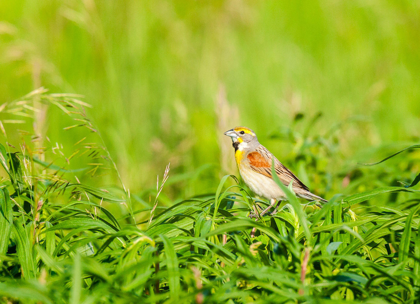
Midewin National Tallgrass Prairie is a fine location to photograph birds. A key to a good photo is finding good perches the birds will land on to separate themselves from the background.

Dickessel in prairie grasses

Dickessel in prairie grasses

Nice portraits are available when they can be isolated.

Dickessel Midewin Tallgrass Prairie

Dickessel Midewin Tallgrass Prairie

Goldfinch in a thorny situation

Goldfinch in a thorny situation

Last year, some new perches were introduced.

Cowbirds on Bison

Cowbirds on Bison

Cathedrals

Cathedral Valley is a remote spot in Capitol Reef National Park, Utah. After a rough road in through high country forest, the land opens to an arid, elevated valley, aptly named after the cathedral-like monoliths inside.

Cathedral Valley, Capitol Reef National Park

Cathedral Valley, Capitol Reef National Park

A ridge on the valley edge allows a view down to the Cathedrals.

Cathedral Valley view

Cathedral Valley view

Stacks

Bandon Beach, Oregon's iconic sea stacks stand sentinel on the coast. They silhouette nicely as the sun sets.

Please read the news at the end of the post. 

Bandon Beach sunset

Bandon Beach sunset

Sea stacks conveniently frame an image.

Sea stack bookends

Sea stack bookends

After the sun sets, a long exposure softens the surf.

Oregon dusk

Oregon dusk

ANNOUNCEMENT:

I will be retiring from the Illinois Education Association at the end of next month. Friday Fotos will not be retiring, but there will be changes. You'll not be getting notice of new blog posts from the ieanea.org email address. If you would like to continue to get email notice when a new post is made, please email me at photos@paulklenck.com and I'll add you to the list. Feel free to share that address and I'm happy to add anyone interested. I'd suggest you add that address to your contacts list or safe senders list. Otherwise, the bulk notice I send might be filtered as spam.

More changes will be coming to the site. Please add your comments to any post, or send an email if you prefer. Cheers!

Marching On

For over 22 years for work I've driven I-55 back and forth to Springfield many, many times. An abandoned farmstead near old Route 66 has captivated me. When the weather and conditions are right, I'll pull over for an image. Here's my earliest with a digital camera. The front porch had recently fallen off the front of the home, and the barn, shed, crib, windmill and other outbuildings were showing their age.

O'Dell farmstead

O'Dell farmstead

The summer storm clouds over the farmland can create a great show.

Summer sunset

Summer sunset

By 2010, the farmhouse had collapsed and the barn was on its way.

Decay

Decay

Some of the windmill and shed are all that are left as I went by this week.

May sky

May sky

The shed continues to shed its skin and lean more toward collapse.

Decrepitude 

Decrepitude 

To be?

White Sands National Monument, true to its name, has expanses of gypsum sand glistening blazing white in the New Mexico sun.

White Sands patterns

White Sands patterns

However, if you stay for dusk, the colors of the sky reflect themselves in the sand.

Dusk color

Dusk color

You can also pay to have a ranger unlock the gates before dawn to enjoy the early morning color.

Morning under the Sacramento Mountains

Morning under the Sacramento Mountains

The New Mexico legislature is considering a bill asking the federal government to change the monument's designation to a National Park. The monument is adjacent to White Sands missile range and south of the Trinity site where the first atomic bomb was tested. The proposal suggests exchanging some land with the test site to allow greater access to dunes.