A walk to the beach

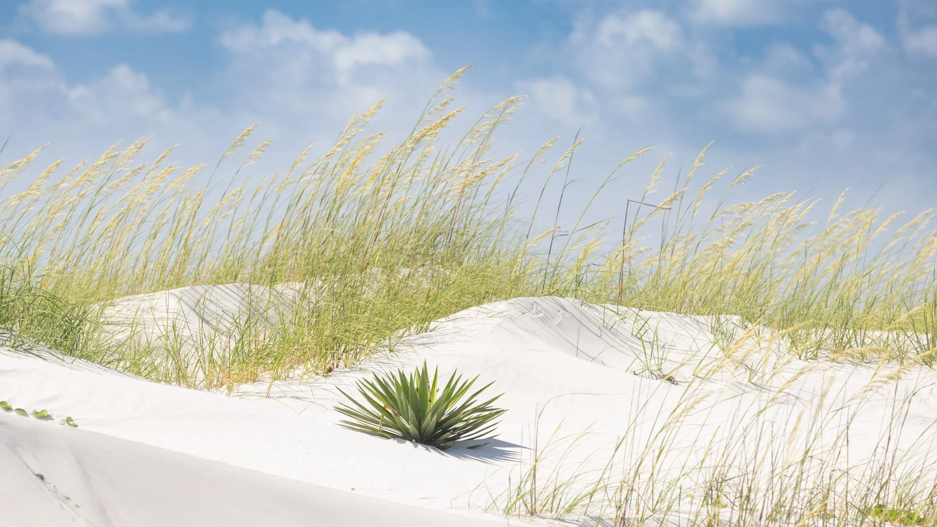
Last week I posted some images of the Live Oaks of Cumberland Island National Seashore. Once you leave the oak forest, you enter the sand dunes before you get to the beach.

Sea oats

One of the best named plants colonizes the drifting sand: Railroad vine.

Railroad vine

In pockets where soil has begun to establish are explosions of wildflowers.

But it is the sea oats that steal the show.

One thing I’ve learned in photography, but too often forget, is to turn around. All these beautiful things beside and in front of you, but what about behind. Surprise.

Time to see the sea over the last dune.

Live Oak

I have many wonderful memories of the Southern Live Oak. Two grew in my front yard in Florida. They were their own ecosystem with lizards crawling among the roots swirling at the bottom, birds pecking and singing above, moss, lichen and ferns growing in the branches.

Southern Live Oak and Spanish Moss

Just north of the St. Mary’s River which is the boundary between Florida and Georgia lies the barrier island of Cumberland Island National Seashore. The center of the island is filled with the Southern Live Oak, the state tree of Georgia. The salt spray and winds are natural pruning agents that keep these trees spreading out relatively close to the ground.

Palmetto and Live Oak

A hardwood hammock near where I grew up was named Deer Head Hammock for the large Live Oak that greeted you as you walked that looked like the animal. Another nearby hammock was named after a mentor of mine—Erna Nixon. The Live Oak can live for centuries. Mrs. Nixon named the two largest trees John and Tom, for John Adams and Thomas Jefferson who would’ve been alive when those trees started (and who both died 198 years ago on July 4th on the 50th anniversary of the Declaration of Independence.)

But on a barrier island with sand dunes near the shore, a tree may not live as long if it gets covered in drifting sand. When the Spanish and British started colonizing the area, they prized the Live Oak to harvest to repair or build new sailing vessels.

The state tree of Florida is the Sabal Palm. You can see one in the image above. Here near the FL-GA line it is appropriate to find a pair snuggling.

I hope you get a chance to get lost for a while in the embrace of a Southern Live Oak.

Sedona -- Pull over

I haven’t posted any poems lately, so let’s read some Mary Oliver. With it are some pictures of a scene that required me to pull the car over and capture the morning sky near Sedona, Arizona. Then I had to find a path and walk down to river that carved out the valley, and enjoy some tree tops and bottoms. And watch the trees and rocks dancing together.

red rocks, sedona, Arizona, bare trees, scalloped clouds

Wild Geese

You do not have to be good.

You do not have to walk on your knees

for a hundred miles through the desert repenting.

You only have to let the soft animal of your body

love what it loves.

Tell me about despair, yours, and I will tell you mine.

Meanwhile the world goes on.

Meanwhile the sun and the clear pebbles of the rain

are moving across the landscapes,

over the prairies and the deep trees,

the mountains and the rivers.

maze of tree branches, mary oliver, wild geese, sedona, arizona

Meanwhile the wild geese, high in the clean blue air,

are heading home again.

Whoever you are, no matter how lonely,

the world offers itself to your imagination,

calls to you like the wild geese, harsh and exciting -

over and over announcing your place

in the family of things.

Mary Oliver, Wild Geese, 2004

If you’d like to hear Mary Oliver reading this poem, click here.

And if you want to see wild geese — scroll down.

Pulling fur on Lake Estes trail

Had a little bit of time on our last morning in Colorado, so headed over to a local parks and rec area nearby called Lake Estes trail. A disk golf course meandered on one side and fly fishers filled the water on the other. There were also fisher fliers.

Osprey

Another adorable family played in the water.

Canada Geese

There was some golden singing in the bushes.

Yellow Warbler

As well as birds seen many times before, I got several to add to my life list, including this one out in the water.

Gadwell

And another bobbed in the creek.

Northern Waterthrush

My most enjoyable encounters were with a common, gregarious show off. While standing looking at some other birds, a magpie landed right next to me on a dead branch. It had a big red berry in its beak. We chatted, and I told it that I had a long lens on and it was way too close for a portrait. It then flew into a nearby bush and to its nest to feed its young. I was able to get a shot of one a little farther away posing with a mountain background in full coat and tails.

Black-billed Magpie

My favorite wildlife encounter of the trip happened as I walked back to the car. I spotted an elk laying under some trees just off the trail. As I looked longer, I saw three elk cows relaxing on the ground. Looking closer still, I noticed magpies were pecking and cleaning the elk’s hooves.

This was a show to sit and enjoy for a while. The elk’s coat was blotchy, losing its long winter fur, and the magpies were jumping up to its haunches and pulling out the long fur. The elk seemed very content to have this team grooming her. Then one of bird really focused on some fur that wasn’t coming off. It dug its beak in and pulled and pulled. The elk had enough, swung her head back, and the magpie flew off. The bird returned, and seemed to apologize. The show was over. Time to get to the car, and head to airport to take wing.

Rocky Mountain Arsenal National Wildlife Refuge

Close to home, I wander occasionally at the Midewin National Tallgrass Prairie, primarily to see birds and wildlife and just to enjoy the prairie. I’ve posted some images from there. A good friend was instrumental in helping to convert that land from use as the Joliet Arsenal into the current state as a major intermodal transport center, Abraham Lincoln National Cemetery and the Midewin Prairie.

On the far western edge of North America’s prairie another army post, the Rocky Mountain Arsenal, sat, unsurprisingly, near the Rocky Mountains. Much of that land has been converted into a National Wildlife Refuge.

American Bison at Rocky Mountain National Wildlife Refuge

While Midewin has also introduced bison into the refuge, I don’t think they have prairie dogs yet. Plenty of those critters wander through Rocky Mountain Arsenal NWR.

Prairie dog in Asters

I added a few birds to my life list while enjoying the trails, such as the Swainson’s Hawk soaring above. I still am surprised to see White Pelicans in the West, thinking they could only be in Florida waters where I saw them growing up, as they swam in a big circle and then closed the circle to trap fish.

Swainson’s Hawk and American White Pelicans

More birds are in the trees. The wonderful Merlin App can even identify them by their songs which helps tell me if I should stop and search more for birds I’ve never seen before.

Spotted Towhee, Blue-winged Warbler, Northern Flicker

And many birds forage on the ground and walk along the trail with me or just to the sides.

Horned Lark and Lark Sparrow

Providing habitat for all are the western prairie grasses which always seem to be swaying in the wind.

Wild Basin, Rocky Mountain National Park

On the east side of Rocky Mountain National Park and south of the heavily visited entrances near Estes Park is an area named Wild Basin.

A spring hike along trails up the North Saint Vrain Creek is filled with frogs calls, squirrel chatter and bird song.

Dark-eyed Junco

The pines rise far above you. A moose was too hidden to photograph, but the trees provide patient subjects.

You can stop along the trail to enjoy Copeland Falls.

And sit by the falls to enjoy the rock shapes, the lichens on them, and the water flowing over and around.

The trail continues climbing upstream along the creek. Around 9,000 feet elevation, the ground is covered with snow, and you come to Calypso Cascades.

Another chance to enjoy the light playing on the rocks and the water.

Might that be a fish jumping in the water?

Time to head back downstream toward the trailhead, and through some aspen.

And revel in the tall pines.

Sakura at the Palace

Large gardens surround the palace in central Kyoto. The cherry blossoms were just beginning to bloom.

Sakura, or cherry blossoms, are an important part of Japanese culture. People gathered on blankets under the trees, posed for pictures, and walked among the blossoming trees.

Sakura has many meanings — life and death, beauty and violence. The season is one of vitality and vibrancy, yet the short-lived flowers remind one of the fleeting nature of life.

The gardens, of course, have far more than the fleeting blossoms. Some pines have enormous bark patches.

Ponds dot through the grounds, and Japanese egrets have time to reflect.

As do herons.

Throughout the country, you are never far from shrines. And reflections are common there as well.

A person may clap their hands to attract the attention of the gods. Also, a suzu rope hangs next to the bell at a Shinto shrine that can be shaken to ring the bell as well. So here’s a Sakura Suzu to end our walk through the palace garden.

The Garden of Origins and Journeys

After a very long day of traveling, and a good night’s sleep, what better place to begin a visit to Japan than at the Garden of Origins and Journeys.

This UNESCO World Heritage Site has many names. Long, long ago Prince Shotoku built a villa here, and in 731 Buddhist priest and bodhisattva Gyoki founded Saihoji 西芳寺 temple. You start your visit in the temple, with shoes off tracing the words of a sutra.

Hundreds of years later, in 1339 Master Zen gardener Muso Soseki restored the temple for the Rinzai Sect. Many noblemen and shoguns visited the temple on their trips to Kyoto. Tea ceremony houses remain throughout the grounds.

The temple also goes by the name Kokedera 苔寺 which translates to Moss Temple. There are said to be over 120 varieties of moss on the grounds. Let’s look at some.

The garden is closed in January and February when the mosses rest. Covered with leaves. When the time to wake comes, gardeners tend the site daily, sweeping leaves off the moss.

The pond in the middle of the garden is shaped like the Japanese character for “heart” or “mind.” Boats once took visitors to three islands in the pond— Horai (Endless Happiness), Tsuru (Crane), and Kame (Turtle).

Rocks in the pond are said to be ships anchored off the coast of Paradise.

Muso Soseki who designed the garden in the 14th century wrote, “It is delusion to think that the pure world of paradise and the profane world of the present are different.”

The temple and gardens are only open for a few hours each day. The admission cost is much higher than any other gardens in Kyoto. The city buses stop a long distance away, as must tour buses, to keep the area quiet, reduce pollution, and let this piece of paradise remain still to be able to journey while in rooted in the Earth.

Kyoto Gardens

Natural places abound in this city of a million and half people. The ancient capitol of Japan has volcanic hills and mountains cut through with streams and rivers. At the top of a preserved historic street of Arashiyama is the ancient Buddhist temple Adashino Nenbutsu-ji, and then above that you can walk through a bamboo forest.

Bamboo forest of Adashino Nenbutsu-ji

Next to the neighbor’s house where I grew up in Florida was dense bamboo thicket. We walked through several bamboo gardens and forests in Japan which transported me back to seeing the immense grasses towering above me as a child. Here though, I could play with my camera and try to recreate a Japanese print.

After walking through bamboo and visiting the gardens, graves and memorials above, we returned to the Adashino Nenbutsu-ji temple. By the temple is Sai-no-kawara, the riverbed of souls which is between the pure land and this world. Funeral rites have been performed here for millennia. The temple began in the 8th century when the Buddhist monk Kukai began placing stone statues for the dead here.

Sai-no-kawara

Perhaps that river to separate the souls flows through the mountains above.

Tenryu-ji is one of five major Zen Mountain temples. The view from the porch of the temple is Sogenchi Pond and the garden surrounding it. Designed by Muso Soseki over 800 years ago, the garden was the first designated Special Historical Scenic Spot of Japan. It is a “borrowed garden” meaning it incorporates the landscape behind.

Sogen-chi Pond garden

Sogen means “source of life".” Emperor Saga first founded a temple here around the year 800. Today, it is one of the seventeen (!!!) UNESCO World Heritage Sites in Kyoto. As I viewed the whole scene, Dan spotted a Japanese Little Egret fishing in the Sogen. Again, I was taken back to Florida and the nearly identical Snowy Egret that lives there. Both have the wispy plumage and the yellow feet, sometimes called golden slippers, which is the easy way to identify them. (If they’ll show you.)

Little Egret in the Sogen

So where to next?

Miyajima National Forest

The United States has 25 World Cultural Heritage Sites designated by UNESCO. The city of Kyoto, Japan has nearly as many. We will visit some. Today, we are going to one just outside Hiroshima, Japan.

A ferry boat ride from downtown Hiroshima takes you across the bay to the island of Miyahima. One of the first sites after walking into the island is the Ohtorri Gate, also known as the floating gate. A Shinto shrine sits on the edge of the bay looking out to the gate which at high tide seems to float on the water.

O’Torri

As you get closer to the shrine, more objects like lanterns envelop you.

Above you is the Gojunoto, or Five-Storied Pagoda.

The forest with blossoming trees beckon you to climb the holy mountain like Kobo Daishi did in 806 CE.

The forest itself is part of the World Cultural Heritage Site. Most of it has never been disturbed. A peaceful path dotted with shrines leads you up the mountain.

You often cross small streams.

Eventually, your pilgrimage takes you to the Miyajima Ropeway; two aerial rope systems that lift you to the top of Mt. Misen. We started in fog and rose into the clouds. At the top, we could look back toward Hiroshima.

Kobo Daishi founded the Buddhist Shingon Sect in the eighth century. Returning to Kyoto, he stopped on Miyajima to climb Mt. Misen. There he performed Gumonji, a 100 day meditative practice before a fire.

The fire has burned for over 1,200 protected under a shrine. Prayer candles are lit from the flame. The flame was taken into to Hiroshima to light the Flame of Peace in the Peace Memorial Park, another World Heritage Site.

The mountain is filled with buildings connected to the Shinto-Buddhist syncretic religion, including the only hall dedicated to demon gods.

The fog did not clear during our stay on the mountain, and we needed to return to the ferry before the tide got too low to return to Hiroshima, and Ground Zero.

X marks the spot - Total Eclipse 2024

In August 2017, I ventured to the Shawnee National Forest in Southern Illinois to see my first total solar eclipse. I posted that story here. To witness dusk suddenly approach in mid-day, then the light switch off, and seeing solar flares shoot out was a phenomenal experience. The area boasted that the next total solar eclipse in the U.S. would cross that very spot.

Image created by Ernest Wright/NASA’s Scientific Visualization Studio

The astronomical odds of an eclipse coming through a specific part of the planet is once every 375 years. I hoped to return to the spot where this occurrence would strike twice in less than seven years. While planning the return, I learned there would be an annular eclipse in late 2023 in the western U.S., so that was a good excuse to head to one of my favorite places to witness that event.

A week before the eclipse, cloudy skies were forecast, but predictions improved as the event approached. But the morning started with dew dripping from the trees enveloped in heavy fog.

Devil’s Backbone, Bell Smith Springs Scenic Area, Shawnee National Forest, Illinois

In 2017, the morning also started cloudy but cleared by the afternoon. Monday, as the fog lifted, blue sky began to show between the clouds. We explored around Mill Branch where I’d watched the prior eclipse, but decided we’d head closer to the Interstate to avoid some traffic when everyone would leave for home.

Mill Branch Creek, Shawnee National Forest

People gathered, blankets were spread, viewing glasses came out, the light dimmed, and the temperature dropped.

Then the switch turned off, the sky darkened, the horizons glowed in sunset colors, and a planet twinkled in the dark sky.

The lights in the corner of this image were from a jet following the path of the eclipse.

For four minutes, we watched the corona dance. In 2017, Southern Illinois was the spot the eclipse lasted the longest at 2 minutes and 40 seconds. That year, the sun was nearing solar minimum meaning fewer coronal ejections. This year, the moon was closer to the earth, blocking more of the sun, and the sun was approaching solar maximum with flares and loops streaming further out.

Then a hint that the show was about to end: the sun began to peak out.

Diamond Ring

As the eclipse was ending, more high circus clouds moved in. But for four minutes, time stopped and the clouds stood by. One orange solar flare at the edge of the sun now peaking from behind the moon cast its last glow.

Chiricahua National Monument

The Chiricahua Mountains rise out of the Chihuahuan Desert in southeast Arizona and extend into Mexico. Driving from the relativity lush, cactus-filled Sonoran Desert to the east, the Chihuahuan Desert is pretty barren and bleak. Then suddenly, high mountains with snow at the peaks rise up. These areas are called Sky Islands with richer biology.

Chiricahua National Monument, Arizona

The spectacular geologic features of the area led to the creation of this national monument in 1924. The Rhyolite rock created by massive volcanos over 25 million years ago has been uplifted and then weathered away.

When the lava cooled, vertical joints formed. Over millions of years, water froze and cracked open the joints. Further erosion carved pinnacles, spires, and columns. Time to get your hiking boots on.

As you hike down among these features toward the creek running below, you wonder when some of these features may come crashing down.

Many of the rocks seem like giant creatures keeping eye over visitors to this wonderland.

Or perhaps a massive mummy walking among the cliffs.

The hike we took into Echo Canyon was certainly one of the most fun, spectacular hikes at a national park site. It reminded us a lot of the Queens Garden Navajo Loop trail at Bryce Canyon. You walk thru hoodoos and giant rock features, down into a high elevation garden of trees and other greenery. Unlike the red rocks of Bryce, here they are brown and grey and covered in green moss and colorful lichens.

In this year of its 100th anniversary at a national monument, a bill is in Congress to designate it a National Park. While it certainly has the vast wonders of many of the western Parks, the current infrastructure would not handle the likely crowds that would follow such a designation. Single road into the park is narrow and twisty and the parking lots are small. I hope the change does not occur. The beauty and diversity of the place will be the unchanged. Just more people will visit. Now you know about it, so come and enjoy the Sky Island wonderland.

Grand Views

Still travelling in Arizona, but here’s some quick views of the Grand Canyon.

Grand Canyon National Park

These images are from the east end of the South Rim Drive at an area called Desert View where there’s a great tower designed by Mary Colter, who is sometimes called the mother of National Park architecture.

Desert View

Looking West

A little further west on the rim drive is this view into the canyon. You can see one of the trails heading down to the river.

"Secretly, joyfully, clearly"

A last few images from Iceland as it is now almost exactly a year since they were taken. A couple weeks ago I posted images of the Reynisdrangar sea stacks taken from the east side of the mountain Reynisfjall that runs to edge of the Atlantic. It’s a bit of a drive to get to west side. Here is that western view of what the legend says are two trolls who tried to land a ship here and froze into rocks when daylight came.

Reynisdrangar

In Snow Geese, Mary Oliver writes of her experience of once, and only once, seeing snow geese migrating overhead. She starts the poem:

Oh, to love what is lovely, and will not last!

What a task

to ask

of anything, or anyone,

yet it is ours,

and not by the century or the year, but by the hours.

. . . .

Skaftafell glacier

. . . I

held my breath

as we do

sometimes

to stop time

when something wonderful

has touched us

. . .

Dawn on Diamond Beach at Jökulsárlón

. . . .

I have never

seen them again.

Maybe I will, someday, somewhere.

Maybe I won’t.

It doesn’t matter.

What matters

is that, when I saw them,

I saw them,

as through the veil, secretly, joyfully, clearly.

excerpts of Snow Geese, from Why I Wake Early, Mary Oliver 2004

Sunrise on Diamond Beach at Jökulsárlón

I hope we see some things today. If you’d like to read the entire poem, click here.

My son Dan edited a video of these and other south Iceland locations. If you’d like to enjoy it:

https://www.youtube.com/watch?v=Na43YW3Smow

Rise and Fall(s)

When sea levels were higher, Iceland was smaller. Waves crashed into the coast forming cliffs. When the sea receded, the cliffs remained, and waterfalls started carving through the cliffs.

Seljalandsfoss

This waterfall is not far off the Ring Road and an easy walk from the parking area as you can see from the folks walking up. When there’s not ice, you can walk behind the falls. The Seljalandsá river splits above the cliff, with most of the water coming down the main falls, but you can see one of the small falls to the left. Here’s a better view.

You can keep walking below the cliffs. A little over a mile you’ll come to another falls from the Gljúfurá River that is hidden behind a gorge. Here’s a peek.

Gljúfrabúi

It is said that huldufólk, or hidden folk, live inside the gorge. They, and the icy boulders, kept me from exploring inside.

As the climate warms and the water level rises, will the sea be returning?

Addendum

While working on some of these images yesterday, the sun came out for the first time in days, and it warmed up enough to take a walk with just a sweater. So Chance and I circled a nearby lake. And perhaps some huldufólk were living beneath the water. (Though I suspect geese left some footprints.)

Herrick Lake

Cosmic Calendar

We sapiens think so highly of ourselves. Yet we’ve been here for such a ridiculously short period. And something like writing is not even a blink of an eye.

February

Astronomer Carl Sagan described the history of the universe in a one (earth) year calendar. The big bang occurred at midnight January 1st, with the basic elements created in the first three seconds. It took until February for the oldest stars and galaxies to begin to form.

March

Around mid-March our Milky Way began to form.

September 9

Our solar system was starting its formation around September 9th.

So what wisdom resides within these rocks and simple elements? How might we tap into that? A hummingbird sees different light wave lengths than we do, and the speed at which the bird travels might be perceiving a different shape of the world. Might a centuries old tree sense time and the environment around it in ways beyond our imagining?

September 14

Earth began to take shape a few days later, and perhaps only ten days more, the very first simple life forms started.

These images are from Reynisdrangar beach near the village of Vik, Iceland. Vik means Viking, and they had a legend that the three-masted troll ship you see in the back ran aground here. Iceland is new land on this planet. As the European and North American continents pull apart, right here lava flows up. After millennia of erosion, these basalt formations take shape. A camera can lengthen time a bit, and let us see the sea dancing and playing with these rocks—eroding and shaping them and pushing the black sand to the shore.

December 20

Around December 20th, plants began to take root on the Earth. Four days later and for five days, dinosaurs spread in the sea and on land.

December 31, late in the day

About 10:30 p.m. the first humans appeared. At 11:59:51, the alphabet was created. Buddha and Jesus were born about 400th of a second later. Around 11:59:58 some of those Vik Vikings might’ve made their way to the North American continent.

Skaftafell National Park

We’ve had nearly a week here of temperatures below freezing, and several more days to that to come. So it’s appropriate to think of a place called Iceland. Skaftafell National Park sits between the ocean to the south and the giant Vatnajökull glacier to the north. In the park, you can hike up the mountain for a view of a giant tongue of that glacier breaking through the mountain and working its way to the sea.

Skaftafellsjökull

Jökull is Icelandic for “glacier,” so I suspect you can figure what Skaftafellsjökull means. Here’s the view south from the same vantage looking as the glacier moves toward the ocean. I trust you can spot my son Dan.

Skaftafellsjökull

If you look at the highest point of the top of the mountain on the other side of the glacier, you can imagine piecing the two images together to get a sense of the full view. And here’s a switch from the wide angle lens to the telephoto to get a closer view of that peak.

The three mile loop trail continues away from the glacier view to several waterfalls that come down the mountain. Oh, and the Icelandic word for waterfall is foss. So here’s one of the more dramatic—Svartifoss. You can see it carving through the columnar basalt created as the lava cooled.

And I just checked the weather report. Yep, colder here today in Northern Illinois than Iceland.

Svartifoss

Epiphany

Marriam-Webster:

a(1): a usually sudden manifestation or perception of the essential nature or meaning of something

(2): an intuitive grasp of reality through something (such as an event) usually simple and striking

(3): an illuminating discovery, realization, or disclosure

b: a revealing scene or moment

St. James Farm Forest Preserve, DuPage County

Marriam-Webster:

capitalized : January 6 observed as a church festival in commemoration of the coming of the Magi as the first manifestation of Christ to the Gentiles or in the Eastern Church in commemoration of the baptism of Christ

St. James Farm Forest Preserve

To celebrate Epiphany, our community sang a song written in 1857: We Three Kings of Orient Are. John Hopkins’ verse is definitely mid-nineteenth century turgidity. (Marriam-Webster: Turgidity: excessively embellished in style or language) Then it ends in a wonderful last verse: “Alleluia, Alleluia” sounds through the earth and skies.

Blackwell Forest Preserve, DuPage County

How to be attuned to the Alleluia that sounds through the earth and skies? It is always there, and most everywhere. But winter storms in a forest let it resound.

St. James Forest Preserve

And sometimes a friend stops to say: “Look here.”

Herrick Lake Forest Preserve

So let’s look closer.

Herrick Lake Forest Preserve, DuPage County

In 1914, following urging by landscape architect Jens Jenson, and urban planner Daniel Burnham, the voters of Cook County established the first forest preserve in the country. The next year, neighboring DuPage County, where all these images are taken, voted to create forest preserves there. The following year, Congress created the National Park Service. All places to hear the Alleluias.

Herrick Lake Forest Preserve

Walking in the woods was like being in a snow globe.

Herrick Lake Forest Preserve

Epiphany was celebrated as a holiday even before Christmas. Eventually, the church set Christmas Day as December 25 and Epiphany as January 6. Epiphany Eve was called the Twelfth Night. This winter we saw a wonderful production of Shakespeare’s Twelfth Night. It starts: If music be the food of love, play on.

Herrick Lake Forest Preserve

Father and son Ben and David Crystal have just published a new book—Everyday Shakespeare: Lines for Life. They have a theme for each month, a quote for each day, and some commentary. For March 26th, they have a line from Twelfth Night, and provide this context: “The sea captain Antonio has been arrested for setting foot in Illyria. He asks the disguised Viola for help, supposing her to be his friend Sebastian (who turns out to be Viola’s lost twin brother) . . . When he/she refuses, Antonio is distraught, and harangues him/her for being so shameful.”

In Nature, there’s no blemish but the mind,

None can be called deformed, but the unkind.

And the Crystals comment: “Perhaps the only blemish (“fault”) in life is the way we think, or the way we treat each other. Be kind. (Especially to yourself.)

St. James Farm

Nebraska

The last large state to cross on the return of my fall trip was Nebraska. I started in the southwest part of the state crossing over from Colorado. The autumn colors were still strong, though not the aspen and cottonwoods. Definitely on the plains.

Not many animals to see except for a variety of raptors searching the rolling land for prey I could not see.

After visiting Scots Bluff, I continued north to another National Monument—Agate Fossil Beds. Near the end of the 19th century, James and Kate Cook found fossil bones on a hill on their ranch. It became the largest collection of giant Miocene mammals ever found.

Agate Fossil Beds National Monument, Nebraska

While there’s not much to explore on the land of the monument, the visitor center museum displays a phenomenal collection of the fossils. But that’s only half of the amazing collection. The Cooks became trusted friends of the Lakota who gifted them with many artifacts including a buffalo hide with the story of the Battle of Greasy Grass a/k/a Little Bighorn.

Chief Red Cloud was a good friend and Lakota and Cheyenne would visit the Cooks filling the surrounding lands with their tepees. You need to image them and the bison today.

After camping in Nebraska National Forest (yes, it surprised me, too, that there was a forest in Nebraska), I awoke to a land covered in fog.

The sandhills along the Niobrara River had a special beauty as I travelled the entire length of the state in fog.

A few cottonwoods appeared out of the mist.

It was a quiet, peaceful end to the trip as I headed eastward, home.

Capulin Volcano

A gift of travel is finding spots on maps that grow and come alive. As I planned earlier trips to the area, Capulin Volcano National Monument hung up on the northwest corner of the map of New Mexico just south of Colorado. I kept looking at the spot, and wanted to visit, but the logistics just did not work out on prior trips. On this trip it would be the final stop before leaving New Mexico.

Capulin Volcano

Approaching from the south in the morning, you can see the road that winds up the cinder cone. The road ends on the little bright spot on the top left. From there, you can hike a mile around the top ridge or head down into the crater.

Capulin Volcano crater

By finally scheduling a stop here, I was lucky to arrive at peak autumn color at the end of October. Looking down to the lava flow plateau below the rim trail, the clusters of fall color popped out. Capulin erupted about 60,000 years ago, so enough time has elapsed for soil to level the ground and plants to grow.

And more color erupts right at your feet.

The pinyon pine is the state tree of New Mexico. This one on the rim likely gave lots of nourishing nuts to birds, squirrels and deer over its life. It now provides some drama to the view.

In all directions from the rim, a smooth plateau of old lava flows extend to more distant cones and shield volcanos. All the dots on the map came alive.