The Lady of Loch Ness

No monsters were seen on the Loch, but we were given directions to a waterfall in a nearby glen. You turn by the garage for the sign for the cemetery (accents on the first syllables of “garage” and “cemetery,” don’t you know.) You’ll walk through the graveyard, and find steps over the cemetery wall.

Lady falls cemetery stairs-3380.jpg

You’ll continue along a farm and see lots of sheep.

Lady falls wall-2.jpg

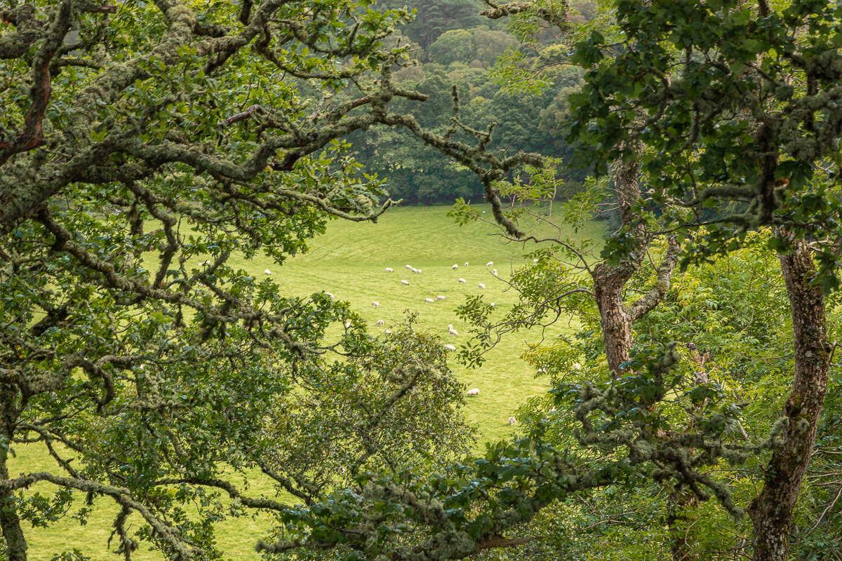
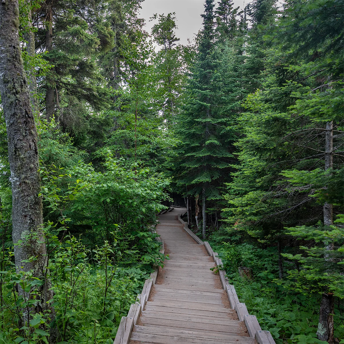
The paths will be green, and you’ll get soaked in the rain and while rubbing against the ferns crowding the trail, but the trees will point the way.

Lady falls green trail-3061.jpg
Lady falls curve oak-3274.jpg
Lady falls oak drama-2.jpg

There may be some locals who keep an eye on you so you don’t disturb the heather and the aspen.

Lady falls ferns heather-2.jpg
Lady falls deer-3073.jpg

Finally, you will be presented to the Lady in her white gown.

Lady falls fall path-2.jpg
Lady falls falls-2.jpg

103: 419, 61

The National Park Service celebrated its 103 anniversary this week. There are 419 park units including National Memorials, National Historic Sites and National Preserves, but the premier status is that of National Park of which there are 61. They are of incredible diversity, and present great photo opportunities. Let’s start with some wide scenes, and what’s grander than the Grand Canyon in Arizona?

Sunset on the North Rim, Grand Canyon National Park, Arizona

Sunset on the North Rim, Grand Canyon National Park, Arizona

North of the Grand Canyon are more spectacular desert vistas in southern Utah. The greatest collection of natural arches is in Arches National Park, and here’s Double Arch with some hikers to give perspective.

Double Arch, Arches National Park, Utah

Double Arch, Arches National Park, Utah

The park service protects the highest spot in the continent at Denali, and here’s the lowest—Badwater Basin in Death Valley.

Badwater Basin, Death Valley National Park, Nevada

Badwater Basin, Death Valley National Park, Nevada

Those are all pretty barren! How about some parks with a focus on preserving incredible biodiversity, and their names reveal the stars.

Sequoia National Park, California

Sequoia National Park, California

Dusk, Saguaro National Park, Arizona

Dusk, Saguaro National Park, Arizona

Two parks preserve remnants of the vast hardwood forests that once covered the eastern portion of the continent. One of the newest parks is Congaree and protects river bottomland hardwood forests mainly of cypress and tupelo. Great Smoky Mountains has vast ridges of high mountain forests. Happy Birthday, National Park Service.

Tupelos along the boardwalk, Congaree National Park, South Carolina

Tupelos along the boardwalk, Congaree National Park, South Carolina

View from Clingman’s Dome on the border of Tennessee and North Carolina, Great Smoky Mountains

View from Clingman’s Dome on the border of Tennessee and North Carolina, Great Smoky Mountains

Out of the mist

How about a bit of a poem from Mary Oliver and some images from a morning at a friend’s place in the Northwoods of Wisconsin. To get the full flavor, you should read the whole poem: Mornings at Blackwater, from Red Bird, 2008, Mary Oliver.

Wisc lake pads pier-7269.jpg

. . . .

What I want to say is

that the past is the past,

and the present is what your life is,

Wisc lake dawn-2.jpg

and you are capable

of choosing what that will be,

darling citizen.

Wisc lake Iris-7187.jpg

So come to the pond,

or the river of your imagination,

or the harbor of your longing,

Wisc lake sun star-2.jpg

and put your lips to the world.

And live

your life.

Wisc lake boat float-7320.jpg

Temperance

A cleverly named river flows into Lake Superior’s North Shore. Most of the rivers have a sand bar that extend out into the Lake, but the Temperance has no bar—thus temperant. Further upstream in Temperance River State Park the Superior Trail leads to a place called Hidden Falls.

Superior hiking trail

Superior hiking trail

Eventually the trail leads to the Temperance River and the falls surrounded by pine, birch, spruce.

IMG_8447-3-2.jpg
Hidden Falls, Temperance River State Park, Minnesota

Hidden Falls, Temperance River State Park, Minnesota

Do you see the doughnut in the image above? There’s often foam in white water that will gather in eddies, but this cove created a five foot toasted coconut doughnut.

IMG_8576.jpg

Some hikers came from the other direction and enjoyed diving into the deep pools by the falls. It is Minnesota after all, so wet suits are good idea even in July.

_MG_6818.jpg

I’ll leave you will a long exposure view of the boulders in the river.

IMG_8513.jpg
IMG_8501.jpg

More fishing

The morning started with some fog over the water.

Fish jump seagull sunrise-8602.jpg

Soon I noticed the water was boiling with fish near shore. The tiny bait fish swirled on the surface indicating big fish were going after them below, and this attracted the birds to after them from above. And a few folks were going after them from aside.

Fish jump beach dolphin-8668.jpg
Fish jump beach-8640.jpg
Fish jump fisherman-8657.jpg

After leaving the beach, and crossing the inter-coastal waterway, I had to pull over because of the beautiful green reflection on the water. There were more fisherman bringing their catch in, dolphins and pelican gathering their catch, but this Great Blue Heron captured my attention. It seemed as if the mullet were teasing him, but he eventually found the target.

Fish jump Great Blue Heron-8368.jpg
Fish jump Great Blue Heron-8337.jpg
Fish jump Great Blue Heron-8347.jpg

Flights of fish

Perhaps you’ll enjoy a flight of beer or wine this evening. This couple enjoyed their flights of fish.

Tricolor heron looking over the menu

Tricolor heron looking over the menu

Selecting the first sample

Selecting the first sample

Tossing back the next delicacy

Tossing back the next delicacy

Snowy herons were on the verge of extinction when their feathers were in high demand for hat fashion. They are petite herons, but aggressive and territorial. You can identify them by their “yellow slippers” which the one below drags along.

Snowy heron dipping in for the first sample

Snowy heron dipping in for the first sample

Selecting number two

Selecting number two

Finishing with a flourish

Finishing with a flourish

Floating on memories

Each spring break in high school, a large group from the Honor Society would load up cars with gear and head to Ocala National Forest and set up camp at Juniper Springs. We’d hike on the Florida Trail, play games around the campfires and on picnic benches, and when it was time to cool off, it was short walk down the trail to the springs.

Juniper Springs, Ocala National Forest, Florida

Juniper Springs, Ocala National Forest, Florida

As with much of the infrastructure we enjoy in our federal and state parks, most of the work here was constructed by the Civil Conservation Core in the 1930s. As you can see in the picture above, where the large pool drains into Juniper Creek, a millhouse and waterwheel was built. The campground and pool were far from any electric lines, so the CCC waterwheel produced electricity for the recreation area.

Juniper Springs Waterwheel and spillway

Juniper Springs Waterwheel and spillway

Juniper Springs Millhouse

Juniper Springs Millhouse

The creek flows on towards the St. John River. A beautiful stone bridge over the creek is closed, but is an exquisite ruin for now. Perhaps, it will be repaired one day. Perhaps, our country will again recognize the value of national service for our young people as a way of enriching our schools, parks, and infrastructure.

Stone bridge, Juniper Springs

Stone bridge, Juniper Springs

While the pool contains the large springs which is the main source of the creek, other spring-fed creeks feed in and at many places along the creek more cool, clear water bubbles up from more springs.

Juniper creek

Juniper creek

The highlight of our annual trip was the canoe run. We’d pack the aluminum crafts with lunch and drinks and head downstream. The beginning of the run is narrow and winding, but eventually widens and flows into the Juniper Prairie Wilderness. The cool water provides a certain place to escape the Florida heat.

Juniper Spr curtain-0264.jpg
Juniper Spr log-.jpg
Juniper Spr river-0142.jpg

Put this in your pipe

On Tuesday, I wrote about Grand Portage National Monument in the far northeast corner of Minnesota. All the way down to the southwest corner is Pipestone National Monument protecting a sacred location for Native Americans. The space does not quickly reveal its treasures surrounded by the tallgrass prairie.

Tallgrass Prairie, Pipestone National Monument, Minnesota

Tallgrass Prairie, Pipestone National Monument, Minnesota

However, as you walk in, the cliffs of Sioux Quartzite begin to appear. The rocks are often covered with spectacular lichen. As beautiful as these rocks are rising out of the prairie, they are not the rock that has been used for nearly 3,000 years by Indians throughout America.

Sioux Quartzite ridge

Sioux Quartzite ridge

pipestone lichen-6962.jpg

The place continues to slowly reveal itself. As you walk further in, the waters of the Pipestone River create a lush environment of plants and trees.

pipestone ridge-.jpg

Finally, you get to the highlight of the hike — Winnewissa Falls. According to lore and oral tradition this beautiful spot in the prairie became a holy place for the area Indians. Just as it slowly reveals itself today, either the river or bison exposed a layer of soft, red pipestone underneath the hard quarzite. The people found this 14 to 16 inch layer was easy to carve and would become a rich, red color.

Winnewissa Falls

Winnewissa Falls

The Indians found the pipestone was easy to carve into figures or pipes, and the red stone developed a beautiful patina with the oils from human hands. Their stories said the red was representative of ancestors blood. The sacred area was recognized as one to share even among warring tribes.

pipestone teepee-6928.jpg

Today, the monument remains a place where dozens of Indian tribes are issued permits to quarry the pipestone each year. The soft stone is called catlinite, named after Philadelphia lawyer George Catlin, who quit his law practice to paint Plains Indians in the 1830s. He documented the quarrying and carving of the pipestone. The Monument has workstations where Native crafters demonstrate their work on the stone.

pipestone carve-7049.jpg
pipestone carve-7034.jpg

Another of the legends at Pipestone offers that you can sit by the feature called the Oracle and receive some of the wisdom this sacred place offers.

The Oracle

The Oracle

Tettegouche State Park

Minnesota’s North Shore of Lake Superior is a necklace of wonders, and one of the gems is Tettegouche State Park. The southwest edge of the park is the Baptism River flowing into the lake. The Lake is at a record high level. When I was last there about 15 years ago, I hiked well out into this bay to the cliff on the other side of the river. In the far distance you can see the feature called Shovel Point where we’ll hike to.

Baptism River, Tettegouche State Park, Minnesota

Baptism River, Tettegouche State Park, Minnesota

A lovely trail takes you through the birch, spruce, fir, pine and maple forest over to Shovel Point.

trail_7841.jpg
trail_7811.jpg

Parts of the trail open up to views of Lake Superior, or Gichigami in the Ojibway language. The local Indians called themselves Gichigamiwininiwag.

Lake spruce_7541.jpg

The lava flows that helped create the features of the shore expose some of the oldest granite on earth. Here’s a view further northeast from Shovel Point, and then a view back southwest toward the Baptism River where we started. Hope you enjoyed the hike!

north view_7516.jpg
Lake Superior View from Shovel Point

Lake Superior View from Shovel Point

Livingston Storm, I presume

I just read that the two flattest states are Florida and Illinois, which have been my homes my entire life. That doesn’t lead to dramatic landscapes, so thankfully both have great clouds. For Illinois, the most dramatic are this time of year as humidity fills the air and storms role across what had once been prairie and is now mostly corn or soybean farmland.

Sheets of rain, Livingston County, Illinois

Sheets of rain, Livingston County, Illinois

Farmhouse and soybeans under the darkening sky

Farmhouse and soybeans under the darkening sky

Livingston County in north central Illinois produced the third largest soybean crop in the state at nearly 17 million bushels, and the second largest corn crop at 63 million bushels. It has two of the state’s largest prisons—Pontiac for men and Dwight for women. Central Illinois was also ground zero of the founding of the Republican Party, and since 1856 a majority has only voted for one Democratic candidate—Franklin Roosevelt in 1932.

Livingston County corn

Livingston County corn

The biggest structures in the farm belt are the towering silos such as this gathering right along the state road and the rail line.

Silo swirl, Livingston County, Illinois

Silo swirl, Livingston County, Illinois

Death Valley National Park

I looked at a picture of dawn at Zabriskie Point at Death Valley National Park, and realized I’d never posted images of the colorful rock features from my visit there in November. We got up before dawn hoping for a good beginning to the day at the iconic location, and were rewarded with great clouds and color.

Dawn at Zabriskie Point, Death Valley National Park, California

Dawn at Zabriskie Point, Death Valley National Park, California

Dawn color

Dawn color

Clouds returned at sunset when down in the valley.

Artist’s Palette, Death Valley

Artist’s Palette, Death Valley

Skies were clear the next day, but the desert colors still shown in the wonderfully named Twenty Mule Team Trail.

Twenty Mule Team Trail

Twenty Mule Team Trail

Another colorful panorama into the valley from high on Dante’s View on the way out of the park.

Dante’s View, Death Valley

Dante’s View, Death Valley

More from Starved Rock

I know some readers of the blog will be heading to Starved Rock State Park soon, so here are some more images from this wet spring. The closest canyon to the Lodge is French, which has some challenging steps cut into the rock to get down to the canyon entrance and then you hike up the stream to get into the canyon.

French Canyon, Starved Rock State Park, Illinois

French Canyon, Starved Rock State Park, Illinois

At the east end of the park, is the flat trail into Kaskaskia and Ottawa Canyons. You’ll get your feet wet crossing the streams, and likely muddy if the rains continue. The walls of Kaskaskia rise straight up from the valley floor.

Kaskaskia Canyon

Kaskaskia Canyon

At the head of Kaskaskia is a lovely little waterfall that always seems to have logs leaning in the pool.

Kaskaskia Canyon waterfall

Kaskaskia Canyon waterfall

The other branch of the canyon trail leads to the higher Ottawa waterfall. After consistent rains, there is usually a second waterfall. You can walk behind the fall for a view up canyon.

Ottawa Canyon falls

Ottawa Canyon falls

Behind Ottawa falls

Behind Ottawa falls

Canyonlands National Park

I’ve had the urge to return to the wonderful southwest desert parks of Utah. Of the five national parks in the state, Canyonlands has some of the most remote and difficult to get to lands. We only visited for half a day two years ago, so only have a taste for a small portion of the park. There are three main sections of the park, separated by the Colorado and Green rivers which meet in the middle of the park. The Maze is the most remote and is a main feature of Edward Abbey’s classic environmental novel The Monkey Wrench Gang. The Needles is similarly remote and accessible through backcountry hiking. The most accessible section, near Moab, Utah, is The Island in the Sky.

The Island in the Sky section has one of the most photographed icons in the U.S. parks—Mesa Arch. The arch hangs on the western edge of a canyon wall and glows in the reflected sunrise light. And I heard busloads of tourists line up and fight for the best angle. We decided to avoid that spectacle and enjoy a quiet sunrise on the edge of the park, and were rewarded with a glorious, and peaceful, beginning to the day.

Sunrise near Canyonlands National Park looking toward Arches National Park

Sunrise near Canyonlands National Park looking toward Arches National Park

We then ventured to Mesa Arch, and got there as a group of Chinese tourists gathered for a group shot in front of the arch before heading to their buses. After the dawn crowds had left, there were just a few of us left to enjoy the scene, and a tiny bit of the morning sun’s glow still touched the bottom of the span.

Mesa Arch, Canyonlands National Park, Utah

Mesa Arch, Canyonlands National Park, Utah

Mesa Arch

Mesa Arch

At the end of the road in the Island District is a lovely hike from Grand View Point overlooking where the Green and Colorado River join in spectacular valleys carved by the rivers. And the view is grand.

Grand View Point looking to the Green River

Grand View Point looking to the Green River

Island in the Sky

Island in the Sky

Starved Rock in a wet spring

The consistent rain this spring has made the trails muddy and the waterfalls flowing at Starved Rock State Park. One of my favorite hikes is Illinois Canyon which is wide with vertical walls. It ends with big pool, not a high waterfall. It is best in early spring with lots of wildflowers or fall with autumn leaves against the canyon walls, but late spring has some benefits and rich green color.

Illinois Canyon, Starved Rock State Park

Illinois Canyon, Starved Rock State Park

At the other end of the spectrum is the highest waterfall in the park in Wildcat Canyon. The hike usually takes you to the top of the canyon with a nice view into the pool below. Then with a long hike down, you can hike into the canyon.

Wildcat Canyon overlook

Wildcat Canyon overlook

Wildcat canyon falls and pool

Wildcat canyon falls and pool

I find French Canyon to be the most challenging to photograph. The waterfall gently cascades down the wall and then flows out in a narrow creek. The heavy flow from the rain created some nice patterns when looking out the canyon.

French Canyon exit

French Canyon exit

The most dependable water flow in the park is in St. Louis Canyon, and the marvelously carved canyon walls by the waterfall creates a classic Starved Rock view.

St. Louis Canyon waterfall

St. Louis Canyon waterfall

(Almost) To The Moon

Fifty years ago this week, Apollo X came VERY close to landing on the moon as the last flight to test all the components of Apollo. Apollo XI would land in two months. The Apollo X lunar module (Snoopy!) descended to less than 9 miles from the surface. Growing up near Cape Kennedy, I was riveted, and my favorite astronaut, John Young, piloted. He had already flown two Gemini missions, would return to the moon on Apollo 16, and fly the space shuttle.

In the images below, you can see the Vehicle Assembly Building where the Saturn V rocket components would be assembled. The land to the west and north of the launch facilities are now protected by the Cape Canaveral National Seashore and the Merritt Island National Wildlife Refuge. The wetland is a wonderful place for wildlife and landscape.

Merritt Island National Wildlife Refuge

Merritt Island National Wildlife Refuge

Cape Kennedy is now used for private business launches, such as Space X below, as well as military launches at the adjacent Cape Canaveral Air Force Station.

Vehicle Assembly Building and Space X launch

Vehicle Assembly Building and Space X launch

T plus 30 seconds

T plus 30 seconds

In December 1972, I was fortunate to be at the launch viewing stands for the final Saturn V launch, and the only one to occur at night. Each county school was able to send one teacher and student to the launch. Thanks Mrs. Cramer! The Saturn V was the most powerful rocket built, and it was like instant dawn when the five engines fired, and trees and clouds were lit up. As it lifted, the roar and vibrations hit you. Unfortunately, I only had a Kodak Instamatic at the time, not some good telephoto glass.

Space X night launch

Space X night launch

The 50th Anniversary celebrations for the first moon landing in July are gearing up. NASA will be starting preparations for a potential Mars landing. If you want your name to go on the 2020 flight which will send a rover to the planet, submit it to them now.

Merritt Island National Wildlife Refuge

Merritt Island National Wildlife Refuge

Surfing Horses

Well, horses in the surf. These pictures have been hard to edit, because it is so challenging to narrow down the images to choose to show. I attended a sunrise workshop where horses and riders from the Baker Barn ran on Butler Beach near St. Augustine, Florida. The morning we were scheduled to shoot, weather reports showed a thunderstorm hitting right after dawn. For everyone’s safety, the shoot was cancelled, and we hoped it could be rescheduled with the riders and appropriate permits. One photographer was leaving that day, so he talked to one rider who said she’d stay to give her horse a run on the beach anyway. A few of us stayed — and it never rained a drop! It helped to get some practice with this challenging shooting.

horse turn 8756a.jpg

The next morning we were able to reschedule and there wasn’t a cloud in the sky — which meant there would be little color once the sun rose, so it was time for pre-dawn silhouettes.

horse silo 025a.jpg
horse run 477a.jpg

Kari and Buttercup, the team that stayed the morning before did a great jump once the sun got up.

horse jump 9919.jpg

With the sun up, I went into the surf to get a better light angle on the horses, which also allowed you to see their incredible musculature.

horse cowboy vert 2032.jpg

This horse only had his left eye which caused him some hesitancy to run south on the beach because he couldn’t get perspective looking into the ocean. The rider discovered that he would see me and I could be a target, so we had some fun (and a few unsettling moments) to have him run right at me. What an incredible time.

horse vert surf_2330a.jpg

Montrose Magic

Montrose Park in Chicago’s Uptown neighborhood has been a magical place for me. As a child, I used to watch my big brother Herb play 16 inch softball games there. When older, I’d go for walks with girls there. Now, it’s a great place to see birds, and I’ve added many to my life list there.

Incredibly, during the Cold War, part of the beach front served as a Nike missile site. After decommissioning, the area was planted and tended by volunteers to support the migratory birds who would rest during Spring and Fall migrations. Many flyways concentrate along Lake Michigan, and the birds need a place to feed and recover. The tended area of plants, trees and grasses has become known as the “Magic Hedge” Unlike other migratory hot spots where the birds are flitting dots 100 feet high in the forest canopy, part of the magic here is that most are found lower to the ground.

Blue-gray Gnatcatcher, Magnolia Warbler and Common Yellowthroat

Blue-gray Gnatcatcher, Magnolia Warbler and Common Yellowthroat

One bird I added to my life list this year was a Yellow Warbler who found its way to a delightful blooming bush.

Yellow Warbler

Yellow Warbler

Lots of people enjoy this bit of wildness in the heart of Chicago. I had my doubts about this couple who were calling to the birds and encouraging them to come feed, but Hamid had a special touch.

Black-capped Chickadee

Black-capped Chickadee

The nearby beach attracts a great collection of gulls, terns, shorebirds and waders. The harbor, especially in winter, attracts a great variety of waterfowl. My best encounter occurred several winters ago when some Snowy Owls erupted from Canada to better feeding much farther south. An owl or two were spotted in the Montrose area, so I went for a look. I searched for a long time and was fooled by many distant seagulls. As I was thinking of leaving, I saw a large white bird more than a hundred yards away flying toward me. A snowy! He flew directly at me and went a few feet over my shoulder. He flew over the water, and then landed in the grasses and permitted me to get a few portraits before flying off. Those eyes are the last thing many a rodent saw. A pretty cool encounter for Uptown Chicago.

Snowy Owl

Snowy Owl

The Dolphin & the Pelican

Unless you’re equipped for underwater photography, it’s challenging to photograph a mammal who lives in the water. A kayak gets you a bit closer and with a better angle. We were fortunate to go out with a dolphin researcher who leads trips into the Matanzas estuary. Dolphins are matriarchal and the females stay together in pods with their young. They also go in estrous together so they can raise the babies at the same time.

Bottlenose dolphin

Bottlenose dolphin

Estimated baby less than 2 weeks old

Estimated baby less than 2 weeks old

The Ripple Effects Ecotour kayaks leave from area that was once the Marineland park which opened over 80 years ago and was one of Florida’s first large tourist attractions. The University of Florida operates a marine laboratory in much of the old grounds. We were fortunate to get a dolphin and pelican show right in the Matanzas River before we even got to our mangrove estuary destination.

The adult dolphin weigh up to 600 pounds and must eat about 30 pounds of fish a day. Pelicans sometimes take advantage of seeing where dolphin have found fish. I believe it is appropriate etiquette to introduce yourself first.

“May I join you for breakfast?”

“May I join you for breakfast?”

As the dolphin raise through the water, the pelican follows looking for fish stirred up, and then dives in for a meal.

Pelican wake 1220.jpg
Pelican wake_1226.jpg

It is only appropriate to thank your companion for providing the meal.

A mullet in the gullet

A mullet in the gullet

Rose

A couple months ago, I wrote that the memory of the first time I saw Roseate Spoonbills remains imprinted on my mind, and how the sight of them continues to thrill me. One of the wonders of a photo is that it can capture and let us study details we cannot otherwise see. So here are some details from images this week of Spoonies from the St. Augustine Alligator Farm rookery.

You might call Robin a red-breast, but look at me

You might call Robin a red-breast, but look at me

I can grab a branch  or swirl up food from the muck with these

I can grab a branch or swirl up food from the muck with these

I don’t need the eyes of a hawk, but it’s sure nice they match my apparel

I don’t need the eyes of a hawk, but it’s sure nice they match my apparel

Do you agree these are my best feature?

Do you agree these are my best feature?

Sky(lum)'s the limit

I’m attending the Florida Birding and Photography Festival in St. Augustine this week. My first event was a sunrise boat ride into St. Augustine Bay and the estuary. with eight other birders and photographers. As we were heading out, I realize I’m chatting with Scott Bourne who is one of the great bird photographers. He’s also President of Skylum software. I was a bit embarrassed to say I’d purchased their Luminar software but hadn’t yet used it! So now I’m giving it a go. I’m just learning and I’m processing these images on a laptop that doesn’t have the best resolution, so hope these come out OK. Also, learned that Scott’s a great guy!

Sunrise over St. Augustine Bay

Sunrise over St. Augustine Bay

Crossing the Sky

Crossing the Sky

That evening, I did a shoot of the nesting birds at St. Augustine Alligator Farm. Most species were still on their eggs but some Great Egret chicks were getting quite big. This trio acted like squabbling siblings. Even though nearly as large as the adult, and so getting ready to fledge, you can easily tell the difference between the adult in the next image who has breeding plumage and green lores (the areas between the eye and beak.

Great Egret trio, St. Augustine Alligator Farm

Great Egret trio, St. Augustine Alligator Farm

Great Egret_0909.jpg

The next morning I took a kayak trip into the Matanzas River estuary at low tide. Many birds were feeding in the muck and low water. Sometime in the future, I’ll post images of a pelican following a pod of dolphin and feeding the fish they would stir up. As for now, here is a juvenile pelican and a Willet feeding among the oysters.

Juvenile Pelican, Matanzas River estuary

Juvenile Pelican, Matanzas River estuary

Willet feeding

Willet feeding

This morning’s shoot of horses on the beach at sunrise was cancelled because of a threatening storm. One of the photographers was immediately leaving to head home and he convinced one of the riders to stay and hope the storm would pass. It did! So a few of us were able to get some images of this beautiful pair. Thanks Kari Coad!

Butler Beach, St. John’s County, FL

Butler Beach, St. John’s County, FL